Bayt Jibrin
[8] The entire site is located in the Lakhish region of central Israel, between the coastal plain to the west and the Hebron Hills to the east, near the 1949 ceasefire line.
Historically, the site was located on the main road between Cairo and Hebron via Gaza,[9] in an area of plains and soft hills known as the Shfela (Shephelah) in Hebrew.
[14][15] According to historical geographer A. Schlatter, the name Betaris mentioned by Josephus should either be identified with Bittir, or else the 't'[clarification needed] amended to gamma, so as to read Begabrin.
In the late Persian period a Sidonian community settled in Maresha, and the city is mentioned three times in the Zenon Papyri (259 BCE).
[36] The vita[clarification needed] of Epiphanius of Salamis, born into a Christian family near Eleutheropolis, describes the general surroundings in Late Antique Judaea.
[38] Seven routes met at Eleutheropolis,[39] and Eusebius, in his Onomasticon, uses the Roman milestones indicating the city as a central point from which the distances of other towns were measured.
[21] The Madaba Map (dated 542-570 CE) shows Eleutheropolis as a walled city with three towers, a curving street with a colonnade in the central part and an important basilica.
[31] During the Roman-Byzantine era, water was brought into Beit Gubrin (Bayt Jibrin) via an aqueduct that passed through Wādi el-ʻUnqur, a watercourse that originates from a natural spring to the south-west of Hebron, and running in a north-westerly direction, bypassing Idhna on the north, for a total distance of about 25 kilometres (16 mi).
The territory under the administration of Eleutheropolis encompassed most of Idumea, with the districts of Bethletepha, western Edom and Hebron up to Ein Gedi, and included over 100 villages.
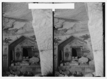
[48] The 1904 Analecta Bollandiana recounts that in 638 the Muslim army beheaded fifty soldiers in Bayt Jibrin from the Byzantine garrison of Gaza who refused to abandon Christianity and who were then buried in a church built in their honor.
[49] In the beginning of the power struggle between Ali and Mu'awiya for the position of caliph, Amr left Medina in the Hejaz and took up residence at his estate called Ajlan in Bayt Jibrin with his sons Muhammad and Abdallah.
The Umayyad prince and governor of Palestine, Sulayman ibn Abd al-Malik, received the news of his becoming caliph in 715 during his stay in Bayt Jibrin.
Bayt Jibrin may have already been devastated in 788,[51] but in any event, in 796, it was destroyed by Bedouin tribesmen in an effort to combat Christian influence in the region during a civil war between the Arab tribal federations of the area.
In 1135, King Fulk of Jerusalem erected a castle on the lands of Bayt Jibrin, the first of a series of Crusader fortifications built at this time to ensure control over the ports of Caesarea and Jaffa.
From 1191 to 1192, the town was held in probate by Henry of Champagne, as lord of the Kingdom of Jerusalem, while Saladin and Richard the Lionheart negotiated a ceasefire.
[10] During Mamluk rule, Bayt Jibrin administratively belonged to Hebron and was under the jurisdiction of the Shafi'i (a school of law in Sunni Islam) qadi (head judge) of that city.
[60] The Ottomans did not exercise strict control over their territories and tended to keep local leaders in their traditional positions as long as they complied with the higher authorities and paid imperial taxes.
[10] During Suleiman the Magnificent's reign, in 1552, the destroyed Crusader castle in Bayt Jibrin was partially rebuilt in order to protect the main road between Gaza and Jerusalem.
[59] In 1596, the inhabitants of Bayt Jibrin, consisting of 50 Muslim families, paid taxes on wheat, barley and sesame seeds, as well as goats and beehives.
[75] The British Army, primarily under the command of General Edmund Allenby, defeated the Ottoman Empire in a series of successful operations in the Middle East, in World War I.
[4] The excavated areas of the successive Judahite, Hellenistic, Roman-Byzantine and Crusader towns have been included in the Beit Guvrin National Park with major points of attraction for tourists.
Furthermore, the Archaeological Seminars Institute, under the license of the Israel Antiquities Authority, conducts excavations of Maresha's many quarried systems, and invites visitors to participate.
Between 1989 and 2000, large-scale excavations were held by the Israel Antiquities Authority (IAA) under the direction of Prof. Amos Kloner and conducted mainly in the Lower City of Maresha, concentrating both on the surface and on the subterranean complexes.
A church on a northern hill of the town, later used as a private residence, had elaborate mosaics depicting the four seasons which were defaced in the 1948 Arab-Israeli War.
Excavations were conducted by the Israel Antiquities Authority (IAA) about 12 kilometres northeast from Bayt Jibrin at a site located on the same wadi, Nahal Guvrin, near moshav Menuha.
Archaeologists believe the villagers grew grain, as indicated by the sickle blades and the grinding and pounding tools, and raised animals that supplied milk, meat and wool, as attested to by the spindle whorls.
The settlement was small in scope, approximately 1.5 dunams, but there is evidence of bartering, based on the presence of basalt vessels and other lithic objects brought to the site from afar.
[97] An example is a woman's jillayeh (wedding dress) from Bayt Jibrin, dated about 1900, in the Museum of International Folk Art (MOIFA) collection in Santa Fe, New Mexico.
Long embroidered headbands made of cotton hanging from both sides were wrapped around the woman's braids to facilitate the bundling of her hair, then secured to the back of the headdress.
[101] In Islamic tradition, Bayt Jibrin is the burial place of the sahaba (companion) of Muhammad, Tamim al-Dari,[10] who was famously known for his piety and briefly served as the governor of Jerusalem in the late 7th century.