Ellington, Cambridgeshire
[4] In 1085, William the Conqueror ordered that a survey should be carried out across his kingdom to discover who owned which parts and what it was worth.
[7] The Domesday Book does not explicitly detail the population of a place but it records that there was 31 households at Ellington.
The Domesday Book uses a number of units of measure for areas of land that are now unfamiliar terms, such as hides and ploughlands.
In different parts of the country, these were terms for the area of land that a team of eight oxen could plough in a single season and are equivalent to 120 acres (49 hectares); this was the amount of land that was considered to be sufficient to support a single family.
[7] The tax assessment in the Domesday Book was known as geld or danegeld and was a type of land-tax based on the hide or ploughland.
A parish council is responsible for providing and maintaining a variety of local services including allotments and a cemetery; grass cutting and tree planting within public open spaces such as a village green or playing fields.
For Ellington the highest tier of local government is Cambridgeshire County Council which has administration buildings in Cambridge.
[15] Cambridgeshire County Council consists of 69 councillors representing 60 electoral divisions.
The village and parish lies on a bedrock of Oxford clay from the Jurassic period.
[4] The A14 road that runs from the Port of Felixstowe to the Catthorpe Interchange, Leicestershire passes through the north of the parish.
In 1932, Ellington was described as being a "curiously shaped parish"[4] from information in the Victoria County History series.
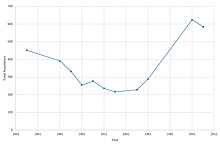
[20] The graph (as pictured) from the census returns show that the population of Ellington, as reported in 1851 was around 450.
[21][22] The chart showing occupational statistics reveals that "Wholesale and Retail" was the most dominant form of employment for the residents of Ellington in 2011.
The earliest occupational statistics of Ellington back in 1831 show the employment fields of the residents were quite different.
[2] The Mermaid Inn is a 17th-century public house that gets its name from the particular type of timber used for the skeleton of the building during construction; today the ancient beams are visible from the bar area and the dining room.
[24] Ellington lies just south of the A14 and 2 miles (3.2 km) from the junction with the A1 road, which southbound, leads directly to the M25 and London.
The nearest railway station is 4 miles (6.4 km) away at Huntingdon which lies on the East Coast Main Line.
Major changes to the A14 nearby have been proposed in different schemes in recent years including one known as A14 Ellington Fen Ditton.
Over the years the church has been changed and updated, such as the south aisle which was either altered or added around the 14th century period.