Elm Grove, Brighton
The densely populated district lies on a steep hill northeast of the city centre and developed in the second half of the 19th century after the laying out of a major west–east road, also called Elm Grove.
Terraced houses, small shops and architecturally impressive public buildings characterise the streetscape: within the area are a major hospital, two churches (all with listed building status) and a former board school, as well as Brighton's oldest council houses and an interwar council estate.
Brighton and Hove City Council's Urban Characterisation Study of the Hanover and Elm Grove districts describes the Elm Grove area[note 1] as a "high density Victorian residential area following the contours of the steep valley side".
[2] The top of Elm Grove close to the racecourse acts as an "important potential gateway into the city" from the east.
[4] The hillside location gives many parts of the Elm Grove area long views in several directions, especially to the west and north.
Thousands were planted in the 19th and early 20th centuries, and there are still more than 17,000—helped by an ongoing programme of Elm disease control by the council.
[7] Brighton's extensive chain of Victorian cemeteries, set into an undulating 100-acre (40 ha) valley formerly used as farmland, lie immediately north of Hartington Road and separate the Elm Grove district from the Bear Road/Coombe Road district,[8] another hillside area of dense terraced housing.
[6] Lewes Road itself was mostly undeveloped as well,[12] apart from six almshouses built on the south side of its junction with Elm Grove.
[13] The first residential development took place between 1854 and 1858 at Melbourne Street and on Wellington Road,[14] which led northeastwards from the bottom of Elm Grove.
It fell into dereliction and was bought by developers Baron Homes in 2006, whose planning application for partial demolition and redevelopment (granted in 2008) lapsed in 2011.
[15] The top (east) end of the road was undeveloped until the late 19th century, except for the Brighton Workhouse—built in 1865–67 to replace an earlier building established in the West Hill area in 1822.
Two landowners donated land north of Elm Grove in 1897, and simple polychromatic brick cottages were built to commemorate Queen Victoria's Diamond Jubilee.
[20] A larger estate of council housing followed in the 1920s with the development of Pankhurst Avenue and surrounding streets on land southwest of the workhouse, as it was at the time.
[24] After the Kemp Town branch line closed, the former railway cutting—a long and narrow area of land between Hartington Road and Elm Grove—became available for redevelopment.
[28] In July 2010 the council announced plans to demolish Ainsworth House, a 1960s low-rise block on Wellington Road, and build a higher-density high-rise "family complex".
[32] Also in 2010, planning permission was granted for the demolition of former nurses' homes facing Pankhurst Avenue and their replacement with three blocks of flats and a community centre.
[33] Hanover and Elm Grove is one of the electoral wards of Brighton and Hove City Council where three local councillors are elected every four years.
[43] The Hanover and Elm Grove Local Action Team (HEGLAT) is a voluntary group which brings together residents of the Hanover & Elm Grove ward and representatives of groups such as the police, council departments, elected councillors, transport operators and other agencies.
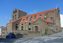
A Catholic chapel which had stood on the site since 1869 was replaced in 1879 with the first part of the present building, which was designed by William Kedo Broder.
[6] Local architect Harry Stuart Goodhart-Rendel was commissioned to design the permanent church once enough money had been raised, and work took place between 1932 and 1934.
[50] Architecturally, the church was "highly original"[45] and "remarkable in its ingenuity",[51] expressing elements of Eclecticism and Rationalism,[52] and inside a mural by Hans Feibusch—his first work in the United Kingdom—has been retained.
[6] The former Emmanuel Full Gospel Church, an Assemblies of God chapel,[53] occupied part of a building on De Montfort Road from 1932 until the late 20th century.
[55] Brighton General Hospital stands at the top of Elm Grove at the Queen's Park Road junction.
Other decoration includes a clock tower with a cupola and a pediment with carved dolphins[57][58] (the Brighton coat of arms).
Brighton & Hove Bus Company route 22 (Churchill Square shopping centre–Woodingdean) runs along the full length of the road.
[19] The heavily engineered line entered the Elm Grove area on a three-arch viaduct across Hartington Road, then passed through a deep cutting, entered the 1,024-yard (936 m)-long Kemp Town Tunnel under Elm Grove School and emerged from the tunnel at the terminus on Eastern Road.
[72] The tunnel has been blocked up (and was briefly used as a mushroom farm) and the cutting filled in and grassed over to form William Clarke Park.
[75] Brighton Corporation Tramways operated tram routes along Elm Grove between 25 November 1901 and 1 September 1939, when the system was closed down.
The end-to-end fare for each route was 2d, and the average journey time from the top of Elm Grove to the Aquarium was 18 minutes.
[77] On race days at Brighton Racecourse, extra trams would be provided along Elm Grove to move large numbers of people to and from the town centre.