Ely, Cambridgeshire
[4] Major rivers including the Witham, Welland, Nene and Great Ouse feed into the Fens and, until draining commenced in the eighteenth century, formed freshwater marshes and meres within which peat was laid down.
There are two Sites of Special Scientific Interest in the city: a former Kimmeridge Clay quarry, and one of the United Kingdom's best remaining examples of medieval ridge and furrow agriculture.
[25] Problems also remain, as pointed out by historian Mac Dowdy, as the word eel (or similar) did not exist at the time of the founding of Ely,[dubious – discuss] and they were instead referred to as aguilla or anguilles until the 1300s.
[27] The city's origins lay in the foundation of an abbey in 673,[28][29] one mile (1.6 km) to the north of the village of Cratendune on the Isle of Ely, under the protection of Saint Etheldreda, daughter of King Anna.
[40] Of similar construction to Cambridge Castle, the 250-foot (76 m) diameter, 40 feet (12 m) high citadel-type motte and bailey is thought to be a royal defence built by William the Conqueror following submission of the Isle from rebels such as the Earl Morcar and the folk-hero Hereward the Wake.
[44] During this time, which became known as the Marian Persecutions, two men from Wisbech, constable William Wolsey and painter Robert Pygot, "were accused of not ... believing that the body and blood of Christ were present in the bread and wine of the sacrament of mass".
[54] During this time Cromwell was a tax collector, though was also one of the governors of Thomas Parsons' Charity,[38] which dates back to 1445[55] and was granted a Royal Charter by Charles I of England.
[61] In the 1607 edition of Britannia,[iv] chorographic surveyor William Camden records that "as for Ely it selfe, it is no small Citie, or greatly to be counted off either for beauty or frequency and resort, as having an unwholsome aire by reason of the fens round about".
[67] Recording in his Rural Rides on 25 March 1830, William Cobbett reports that "Ely is what one may call a miserable little town: very prettily situated, but poor and mean.
Geographer John Jones, writing in 1924, reports that "from the roof of King's Chapel in Cambridge, on a clear day, Ely [cathedral] can be seen on the horizon, 16 miles (26 km) distant, an expression of the flatness of the fens".
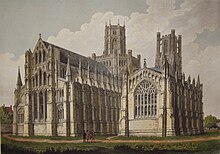
[80] Local historian Pamela Blakeman reports a claim that "Grouped around [the cathedral] ... is the largest collection of medieval buildings still in daily use in this country".
[82] The "special and peculiarly ancient"[83] honour and freedoms given to Ely by charter at that time[84] may have been intended to award only fiscal privilege,[85] but have been interpreted to confer on subsequent bishops the authority and power of a ruler.
[92][93] Ely's city status was not explicitly confirmed, however, until 1 April 1974 when Queen Elizabeth II granted letters patent, to its civil parish.
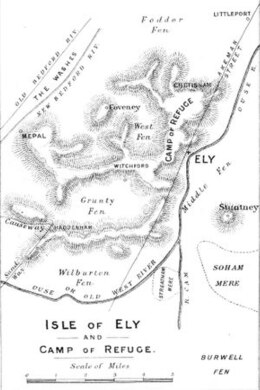
These islands rise above the surrounding flat land which forms the largest plain of Britain[ix] from the Jurassic system of partly consolidated clays or muds.
[30] Kimmeridge Clay beds dipping gently west underlie the Lower Greensand of the area exposed, for example, about one mile (2 km) south of Ely in the Roswell Pits.
[105] The Lower Greensand is partly capped by glacial deposits forming the highest point in East Cambridgeshire, rising to 85 feet (26 m) above sea level in Ely.
Major rivers in the region, including the Witham, Welland, Nene and Great Ouse, drain an area of some 6,000 square miles (16,000 km2)—five times larger than the fens—into the basin that forms the fens.
[108] On 23 November of that year, Church of England cleric and Christian theologician John Wesley, wrote of his approach to Ely after visiting Norwich: "about eight, Wednesday, 23, Mr.
[121] Prior to the extensive and largely successful drainage of the fens during the seventeenth century, Ely was a trade centre for goods made out of willow, reeds and rushes and wild fowling was a major local activity.
A cannon, captured during the Crimean War at the Siege of Sevastopol (1854–1855) and given to Ely by Queen Victoria in 1860, is located on Palace Green, west of the cathedral.
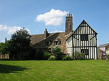
[175] St Mary's Vicarage, better known locally as Cromwell's House, is a Grade II* listed building of mainly 16th century plaster-frame construction although there exist some stone arches, c. 1380.
[185] The Lamb Hotel is a Grade II listed building which is prominently situated on the corner of Lynn Road and High Street 100 yards (91 m) north of the west end of the cathedral.
[193] The former Kimmeridge Clay quarry Roswell Pits, one mile (1.6 km) southwest of Ely Cathedral, is now a nature reserve and Site of Special Scientific Interest (SSSI).
[211] In Bishop John Fordham's survey of Ely in 1416–1417, an east to west Akermanstrete or Agemanstrete is mentioned, which now forms part of the east–west Egremont Street.
[214] Medieval accountant, Clement of Thetford made, or had others make on his behalf, many journeys between 1291 and 1292, as evidenced by his sacrist's rolls—the earliest known roll of the Ely Monastery.
[244] In 1944 and 2021, the Boat Race took place on a course on the Great Ouse on the outskirts of Ely, moved from the River Thames due to World War II and the COVID-19 pandemic, respectively.
[255] The Princess of Wales Hospital in the north of Ely was built during the Second World War by the Royal Air Force, and until 1993 it served nearby RAF stations including Marham, Feltwell, Lakenheath, and Mildenhall.
Other notable people from Ely include The Sisters of Mercy singer Andrew Eldritch,[262] journalist Chris Hunt,[263] nurse Margaret Tebbit who was severely injured in the Brighton hotel bombing in 1987,[264] as well as crime writer Jim Kelly[265] and award-winning poet Wendy Cope.
[267][268][269] The first series of Jim Kelly's crime novels, featuring journalist Philip Dryden, is largely set in the author's home town of Ely and in the Fens.
The album cover for Pink Floyd's The Division Bell was created by Storm Thorgerson with Ely as the background between two massive sculptures that he had erected outside the city.


Joan Blaeu (1648) Regiones Inundatae