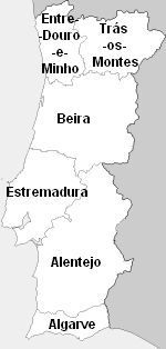
Entre Douro e Minho
The coastline of Entre Minho e Douro is level and unbroken except by the estuaries of the main rivers; inland, the elevation gradually increases towards the north and east, where several mountain ranges mark the frontier.
The Lima or Antela (Spanish Limia) rises in Galicia, and reaches the sea at Viana do Castelo; the Cávado springs from the southern foothills of La Raya Seca, on the northern frontier of Trás-os-Montes, and forms, at its mouth, the small harbour of Esposende; and the Ave descends from its sources in the Serra da Cabreira to Vila do Conde, where it enters the Atlantic.
A large right-hand tributary of the Douro, the Tâmega, rises in Galicia, and skirts the western slopes of the Serra de Marão.
Being seen as a trace of Estado Novo policies, the territorial definitions of 1936, though having innocuous and non-political characters, were erased in 1976 soon after the Carnation Revolution.
Nevertheless, people still use the designations of 1936 on a daily basis because they more or less accurately correspond to the historical identity of the locals e.g.: "Minhotos", "Durienses", "Beirões", "Ribatejanos", etc., and many books and maps still show them.