Thuringian Basin
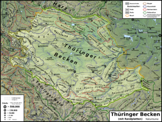
The Thuringian Basin[1][2] (German: Thüringer Becken) is a depression in the central and northwest part of Thuringia in Germany which is crossed by several rivers, the longest of which is the Unstrut.
The Basin is surrounded by a wide outer girdle of limestone (Muschelkalk) ridges (including Hainich, Dün, Hainleite, Hohe Schrecke, Schmücke, Finne), and to the southwest by the Thuringian Forest and to the southeast by sharply divided terraces (the Ilm-Saale and Ohrdruf Muschelkalk plateaus, and the Saale-Elster Bunter sandstone plateau).
In the Cenozoic era the surrounding ridges were uplifted, whilst the Thuringian Basin sank to form a saucer-shaped depression.
Smaller areas used to belong to the Wettin Ernestine duchies and the County of Schwarzburg; the city of Erfurt was a possession of the Mainz Archbishops.
According to the 1815 Congress of Vienna, the Albertine and Mainz lands passed to the Kingdom of Prussia, while the smaller areas on the northern and southern rim formed the Thuringian states.