Euphrates
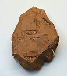
[8] The earliest references to the Euphrates come from cuneiform texts found in Shuruppak and pre-Sargonic Nippur in southern Iraq and date to the mid-3rd millennium BCE.
The Balikh receives most of its water from a karstic spring near 'Ayn al-'Arus and flows due south until it reaches the Euphrates at the city of Raqqa.
Its main karstic springs are located around Ra's al-'Ayn, from where the Khabur flows southeast past Al-Hasakah, where the river turns south and drains into the Euphrates near Busayrah.
[13] Some sources estimate that approximately 15 percent of the drainage basin is located within Saudi Arabia, while a small part falls inside the borders of Kuwait.
[11][12] Finally, some sources also include Jordan in the drainage basin of the Euphrates; a small part of the eastern desert (220 square kilometres (85 sq mi)) drains toward the east rather than to the west.
Species characteristic of this type of forest include the Oriental plane, the Euphrates poplar, the tamarisk, the ash and various wetland plants.
[34] Sixteenth to nineteenth century European travellers in the Syrian Euphrates basin reported on an abundance of animals living in the area, many of which have become rare or even extinct.
[35] The Hindiya Barrage on the Iraqi Euphrates, based on plans by British civil engineer William Willcocks and finished in 1913, was the first modern water diversion structure built in the Tigris–Euphrates river system.
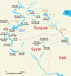
With a maximum capacity of 48.7 cubic kilometres (11.7 cu mi), the Atatürk Dam reservoir is large enough to hold the entire annual discharge of the Euphrates.
[45] Completion of GAP was scheduled for 2010 but has been delayed because the World Bank has withheld funding due to the lack of an official agreement on water sharing between Turkey and the downstream states on the Euphrates and the Tigris.
The creation of reservoirs with large surfaces in countries with high average temperatures has led to increased evaporation; thereby reducing the total amount of water that is available for human use.
[57] The many dams and irrigation schemes, and the associated large-scale water abstraction, have also had a detrimental effect on the ecologically already fragile Mesopotamian Marshes and on freshwater fish habitats in Iraq.
[58][59] The inundation of large parts of the Euphrates valley, especially in Turkey and Syria, has led to the flooding of many archaeological sites and other places of cultural significance.
The combined GAP projects on the Turkish Euphrates have led to major international efforts to document the archaeological and cultural heritage of the endangered parts of the valley.
Especially the flooding of Zeugma with its unique Roman mosaics by the reservoir of the Birecik Dam has generated much controversy in both the Turkish and international press.
[61][62] The construction of the Tabqa Dam in Syria led to a large international campaign coordinated by UNESCO to document the heritage that would disappear under the waters of Lake Assad.
Archaeologists from numerous countries excavated sites ranging in date from the Natufian to the Abbasid period, and two minarets were dismantled and rebuilt outside the flood zone.
[63] A similar international effort was made when the Tishrin Dam was constructed, which led, among others, to the flooding of the important Pre-Pottery Neolithic B site of Jerf el Ahmar.
[65] Parts of the flooded area have recently become accessible again due to the drying up of the lake, resulting not only in new possibilities for archaeologists to do more research, but also providing opportunities for looting, which has been rampant elsewhere in Iraq in the wake of the 2003 invasion.
"[67] This is said to be one of the future minor signs of the coming of Judgement Day:[68] In the Christian Bible, the Euphrates River is mentioned in Revelation 16:12, in the final book of the New Testament.
Author, John of Patmos writes about the Euphrates river drying up as part of a series of events that foretell the Second Coming of Jesus Christ.
Acheulean stone artifacts have been found in the Sajur basin and in the El Kowm oasis in the central Syrian steppe; the latter together with remains of Homo erectus that were dated to 450,000 years old.
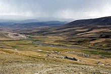
[71][72] In the Taurus Mountains and the upper part of the Syrian Euphrates valley, early permanent villages such as Abu Hureyra – at first occupied by hunter-gatherers but later by some of the earliest farmers, Jerf el Ahmar, Mureybet and Nevalı Çori became established from the eleventh millennium BCE onward.
[73] In the absence of irrigation, these early farming communities were limited to areas where rainfed agriculture was possible, that is, the upper parts of the Syrian Euphrates as well as Turkey.
[76] During the 5th millennium BCE, or late Ubaid period, northeastern Syria was dotted by small villages, although some of them grew to a size of over 10 hectares (25 acres).
[88] Following the end of the Middle Assyrian Empire in the late 11th century BCE, struggles broke out between Babylonia and Assyria over the control of the Iraqi Euphrates basin.
The Neo-Assyrian Empire (935–605 BC) eventually emerged victorious out of this conflict and also succeeded in gaining control of the northern Euphrates basin in the first half of the 1st millennium BCE.
[94][95] A similar crisis, although not escalating to the point of military threats, occurred in 1981 when the Keban Dam reservoir had to be refilled after it had been almost emptied to temporarily increase Turkey's hydroelectricity production.
[93][95][98] In 2008, Turkey, Syria and Iraq instigated the Joint Trilateral Committee (JTC) on the management of the water in the Tigris–Euphrates basin and on 3 September 2009 a further agreement was signed to this effect.
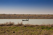
Syria's Lake Assad is the most important source of drinking water for the city of Aleppo, 75 kilometres (47 mi) to the west of the river valley.