European Cenozoic Rift System
The system began to form during the Late Eocene and parts (particularly the Upper and Lower Rhine Grabens) remain seismically active today and are responsible for most of the larger earthquakes in Europe, north of the Alps.
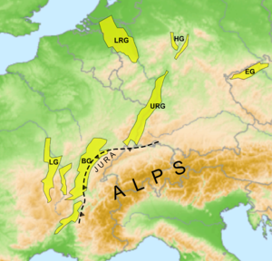
The eastern margin of the basin was overridden by thrust faults from the Jura Mountains, the leading edge of the Alpine thin-skinned deformation.
[2] The Upper Rhine Graben extends from the northern edge of the Jura mountains in the south up to the triple junction where the ECRIS branches.
[1] The easternmost part of the system, the Eger Graben shows two distinct phases of extension at the end of the Eocene and during the early Miocene.
[1] The development of the ECRIS was accompanied (and in some cases preceded) by volcanic activity over large parts of the rift system that persisted into the Quaternary.
The north-eastern branch continues with the Wetterau, the Giessen Basin, the Amöneburg Basin, the Upper Hessian Ridge near Neustadt, the West Hesse Depression, the Leine Rift, part of the Salt dome region in northern Germany, the Kattegat, the Oslo Rift and eventually Mjøsa with Lillehammer at its northern end.
In the area surrounding the Mediterranean-Mjosa Zone there was some volcanism, e.g. Kaiserstuhl or Hoher Habichtswald west of Kassel, which primarily consist of Basalt.