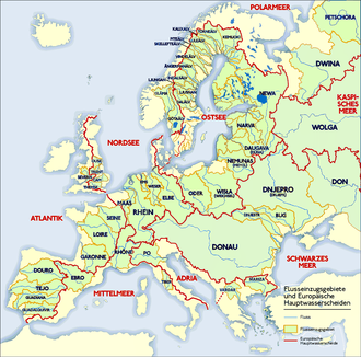
European watershed
It stretches from the tip of the Iberian Peninsula at Gibraltar in the southwest to the endorheic basin of the Caspian Sea in Russia in the northeast.
The Watershed runs northwards through Spain in the Iberian Peninsula towards the Bay of Biscay along the basins of the Guadalquivir,[1] Guadiana, Tagus and Douro in the west to the sources of the Ebro in Cantabria.
[2][3][4][5] It then follows the main ridge of the Pyrenees eastwards up to Andorra, where it again turns to the north through France along the catchment areas of the Garonne (with the summit of the Canal du Midi at Seuil de Naurouze), Loire and Seine in the west and that of the Rhone in the east, marked by the Cévennes mountain range between the sources of the Allier and Ardèche tributaries.
It enters Austria at Piz Buin in the Silvretta Alps, running along the Arlberg massif and forming the border between the states of Tyrol and Vorarlberg.
[7] Within the Alpine foothills it runs north of the Schussen catchment area of Lake Constance towards the sources of the Brigach and Breg headwaters of the Danube in the Black Forest.