Evolution of Worcestershire county boundaries since 1844
Redditch opted to join the West Midlands Combined Authority as an associate 'non-constituent' member in October 2015, although this will not affect the borough's status within Worcestershire.
Worcester's strategically dominant position upon the undulating plains of the River Severn, an important role as an ecclesiastical centre and also the chief point of trade and military communications between the Anglo-Saxon and Welsh kingdoms,[3] rendered it a logical location to serve as a burh.
[7] In the east, Arden became part of Warwickshire, and Winchcombeshire straddled an area bounded by the River Avon, Vale of Evesham and the Cotswold Hills.
Meanwhile, to the north; during Cnut's conquest of Anglo-Saxon England in 1015–16, Mercia was in turmoil and was invaded by Vikings, who seized territory "through force and fraud and secular power".
Meanwhile, Herefordshire, Staffordshire, Warwickshire and Shropshire had their own exclaves within the main part of Worcestershire at Rochford,[39] Broome,[40] Clent,[41] Tardebigge (Tutnall and Cobley)[42] and Halesowen respectively.
[47] By the 19th century the Industrial Revolution started a process of economic, social and physical integration of some Worcestershire towns and villages, with neighbouring communities in Staffordshire, thus creating the urban area known as The Black Country.
[49] Elsewhere in the Halfshire hundred similar integration was taking place with the Warwickshire town of Birmingham, whom was expanding considerably to the south and east of its historic centre.
The proposals would have also seen Smethwick join Worcestershire, plus Burford (uniting all of Tenbury rural sanitary district into one county), Ipsley, Upper Arley, Pebworth and West Malvern.
The non-administrative purposes were stated to be "sheriff, lieutenant (custos rotulorum), justices, militia, coroner, or other",[66] thus resembling the functions of modern ceremonial counties.
The district of Balsall Heath, which had originally constituted the most northerly part of the Parish of King's Norton, was the first area of the county to be added to the newly designated City of Birmingham on 1 October 1891.
[74] The continuous expansion of Birmingham city has been a large contributory factor to Worcestershire's fluid boundary changes and associated housing issues.
The plans included merging Worcestershire with Herefordshire to form a new administrative unit, except Dudley and Oldbury which would become part of a new "Stafford South" county.
This process became more prominent due to growing housing issues, extensive bombing during World War II, slum clearance, and continuing migration into urban areas.
[93] Meanwhile, the second report into the West Midland General Review area was also delivered in July 1961 and a proposal for Worcester to lose its county borough status[94] was not implemented.
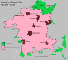
[101] During these reorganisations, the territory of the county council grew only where Stourbridge took in the majority of Amblecote Urban District[102] from Staffordshire (See Fig 9) and the designation of Redditch in April 1964 as a "New town".
[103] Historically, Redditch lay on the county boundary, so any expansion of the newly designated town would either fall under the Green Belt to the north, or the surrounding area of Warwickshire at Matchborough.
[105] Numerous housing developments took place across the county, especially in Droitwich, Worcester and along the Birmingham boundary at Frankley, Hawkesley, Kitwell, Rednal, Rubery and Walkers Heath.
These new unitary (i.e. single tier) authorities were largely based on major towns, which acted as regional employment, commercial, social and recreational centres and took into account local transport infrastructure and travel patterns.
During the debates associated with the Local Government Bill, Terry Davis MP (Bromsgrove) tabled Amendment Numbers 73, 74 and 100 which proposed maintaining Worcestershire and Herefordshire as separate counties.
He continued by stating that "a reason for the support of the county council, which is wholeheartedly for the boroughs of Halesowen and Stourbridge in their opposition to joining the conurbation, is the question of the Green Belt."
Most of the rural hinterland proposed by Redcliffe-Maud was discarded; thus permitting Bewdley, Bromsgrove, Kidderminster, Redditch and Stourport-on-Severn to become part of the new Hereford & Worcester authority.
The individual metropolitan boroughs resumed most services which were provided at county level[126] or through joint bodies such as the West Midlands Passenger Transport Authority.
[132] The last territory exchange between the West Midlands County and Hereford & Worcester or its successor administrative authority occurred along sections of the Birmingham and Bromsgrove district boundary.
The rationale for the proposals were the unification of several housing estates built and maintained by Birmingham City Council, under the Town Development Act 1952, which fell within the Bromsgrove boundary.
[136] Following the Local Government Act 1992 legislation; the LGBCE was once again charged with examining all English non-metropolitan counties, but was given authority to recommend proposals that would significantly alter or abolish administrative areas.
[160] Separately, the Secretary of State for Communities and Local Government announced on St. George's Day 2013 in a symbolic move that England's historic and traditional counties still exist.
[166] A follow-up announcement in April 2014 put forward an initiative in changing planning regulations, stating that 'traditional county' names can be placed on roadsigns.
Guidance released by the Ministry of Housing, Communities and Local Government on 16 July 2019 sought to bring all of these aspects together into one document - 'Celebrating the historic counties of England'.
[171][172] The subsequent local government restructuring in April 2009 and 2019-2023, which abolished more two-tier counties (including Shropshire, Buckinghamshire, Dorset and Cheshire) did not affect Worcestershire.
[174][175][176][177][178][179][180] Possibilities being put forward in these discussions are broadly similar to the Local Government Boundary Commission for England proposals prior to the 'Hereford & Worcester' abolition.