Extremadura
Extremadura (/ˌɛkstrəməˈdjʊərə/ EK-strə-mə-DURE-ə; Spanish: [e(ɣ)stɾemaˈðuɾa] ⓘ; Extremaduran: Estremaúra [ehtːɾemaˈuɾa]; Portuguese: Estremadura; Fala: Extremaúra) is a landlocked autonomous community of Spain.
Extremadura is bordered by Portugal to the west and by the autonomous communities of Castile and León (north), Castilla–La Mancha (east), and Andalusia (south).
[5] Besides the catchment basins of the Tagus and the Guadiana covering most of the territory by far, fringe areas of the region are drained by the Douro (north) and the Guadalquivir (south).
Notable Tagus tributaries include the Tiétar and the Alagón (rightbank) and the Almonte, Ibor, Salor and the Sever (leftbank).
The highest point in Extremadura, the 2,401 m (7,877 ft) high Calvitero (or El Torreón),[6] is located in the Sistema Central, in the northeastern end of the region, bordering with Castile and León.
[8] Extremadura generally presents average annual temperatures somewhat warmer than most of the hinterland of the Iberian Peninsula, featuring nonetheless a north–south gradient.
As part of the Emirate and later Caliphate of Córdoba, it largely constituted a territorial subdivision (kūra) of the former polities centered on Mérida.
Following the collapse of the Caliphate in the early 11th century during the so-called Fitna of al-Andalus and its ensuing fragmentation into ephemeral statelets (taifas), the bulk of the territory of current day Extremadura became part of the (First) Taifa of Badajoz (Baṭalyaws), centered around the namesake city and founded by Sapur, a saqaliba previously freed by Al-Hakam II.
[12] Conversely, the kingdoms of León, Castile and Portugal (most notably the first one) made advances in the 11th and 12th centuries across the territory (with for example the successive Leonese conquests of Coria in 1079[13] and 1142,[14] the Portuguese attempts at expanding across the Guadiana basin in the second half of the 12th century,[15] or the Castilian founding of Plasencia in 1186)[16] not free from setbacks either caused by the Almoravid and Almohad impetus, which also entailed the demise of the first and second taifa of Badajoz in 1094 and 1150,[17] respectively.
[18] After the Almohad disaster at the 1212 Battle of Las Navas de Tolosa, the remaining part of current-day Extremadura under Muslim control fell to the troops led by Alfonso IX of León—Alcántara (1214),[19] Cáceres (1227–1229),[20] Mérida (1230),[21] Badajoz (1230)[22]—and later to the military orders of Santiago and Alcántara—Trujillo (1232),[23] Medellín (1234)[24]—on behalf of Ferdinand III of Castile.
[34] Located in the most able path from the Meseta Central to Portugal, the territory suffered greatly due to warfare from the 1640–1668 Portuguese Restoration War,[35] characterised not by the movement of large armies but for pillage, skirmishes, raids, and destruction of economic resources and settlements across both sides of the Raya.
[36] The growing role of the fortified place of Badajoz (halfway between Lisbon and Madrid), in the wake of the installment of the Captaincy General of Extremadura consolidated the clout of the military in the region.
[39] The growing cattle sector induced the creation of yet more pastures,[39] adding up to the structural problem stemmed from the extraordinary degree of concentration of land ownership.
[38] By the end of the Ancien Régime, the clergy, municipal councils and the royal army mattered more than the lesser role of the entitled nobility.
[43] During the 1936–1939 Spanish Civil War, the Nationalist faction Columna Madrid advanced quickly across the province of Badajoz in August 1936 and left merciless repression and mass casualties behind.
[45] In the mid 20th century, the Francoist dictatorship pursued a policy of colonization and agrarian reform in the region to foster the economy, transforming thousands of hectares of dryland crops into irrigated lands, also favouring the erection of 63 new settlements by the Instituto Nacional de Colonización (INC).
[47] The region henceforth was handed a demographic blow in the ensuing years, with the effective expulsion of nearly a 40% of the population, particularly young people.
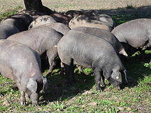
At that time, enough US restaurants were in demand for the delicacy that Spain decided to export it as boneless, which the US Department of Agriculture's health codes would approve (and continue to do).
[63] This situation has led to the characterization of Extremadura as a potential "colony" of the private electricity companies, which are not taxed in the region and employ a relatively low share of the industrial workforce.
[64] As of 2021, the region has around 2,193.84 MW of installed hydroelectric power, primarily controlled by Endesa and Iberdrola, with a lesser role of Grupo Pitarch.
[65] The region is at the forefront of Spain's plans for energy transition and a decarbonisation, thanks to the installation of large solar power plants and the granting of lithium mining licenses.
[66] Such prospects sparked criticism and concern regarding how to avoid a "third energy colonisation" after those of the construction of reservoirs for hydroelectric use and the building of nuclear power plants.
[67] A project to build a lithium-ion battery factory participated by Envision in Navalmoral de la Mata was announced in June 2022.
The urban network is dominated by three municipalities between 50,000 and 200,000 inhabitants (Badajoz, Cáceres and Mérida), followed by Plasencia, the Don Benito-Villanueva de la Serena conurbation and Almendralejo.
Reported phonological distinctive features of the Spanish dialectal variants spoken in the region include instances of seseo (in some areas of the province of Badajoz), loss of intervocalic /d/, j and word-initial h aspiration, r → l substitution, and yeísmo.