Farrar's Island
The county operates the Dutch Gap Conservation Area and Boat Landing and as well as a living history museum, the Henricus Historical Park.
At that time, Farrar's Island was slightly less than 700 acres (280 hectares) and lay about 15 miles (24 km) south of the James River fall line at Richmond, Virginia.
Due to its strategic location on the river, the peninsula's neck became the site of the earliest English settlements in Virginia, Henricus, founded by Sir Thomas Dale in 1611, but basically abandoned by 1622.
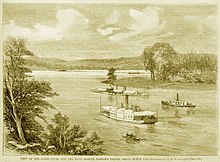
In the 1870s, the Dutch Gap Canal was expanded and become the main channel of the James River, which allowed shipping to bypass the meander loop around Farrar's Island.
Construction of the canal put Farrar's Island on the west side of the James River, and it evolved into its present form as a tidal lagoon surrounded by woods and wetlands.
[10]: 27 The Virginia Company of London had ordered Dale to find a healthy location to secure the navigable portion of the upstream James River and to provide a place of retreat in case of an attack by the Spanish.
[15]: 25 : 32 : 35 Though Henricus was incorporated into the City of Henrico, what was left of it was abandoned after the Powhatan attack of 1622, as the settlement was not listed as one of the fortified strongholds that the Virginia Company ordered survivors to move to.
[18] In May 1771, twelve days of heavy rain in the mountains west of Richmond caused a deluge known as "The Great Fresh of 1771", which inundated the settlements and plantations along James River.
All the property of the then owner, Thomas Mann Randolph was carried off by the flood,[20] and the land's economic value was also severely reduced as 80 acres of arable topsoil washed away, leaving a pavement of stones.
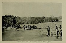
In June 1864, General Ulysses S. Grant ordered the Union navy under Admiral Samuel Phillips Lee to sink five ships,[25] which were then used to create an obstructive boom across the James River stretching between Farrar's Island and Trent's Reach.
[33] Richard Friend, who inherited the property from Cox in 1888, filed suit against the United States Government to recover his claimed losses due to the improvement of the canal, but lost his case.
[37] In 1983, another 103 acres of Farrar's Island was transformed into an ash pond for the nearby Dominion Chesterfield Power Station located on the Dutch Gap Cutoff on the James River.
Facing environmental criticism in 2016, Dominion planned to move toxic coal ash from the pond on Farrar's Island to a lined landfill at the Chester Power Station.