Fernando de Noronha
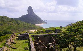
In 2001, UNESCO designated it as a World Heritage Site because of its importance as a feeding ground for tuna, sharks, sea turtles, and marine mammals.
Due to its geographical position, the archipelago was one of the first lands sighted in the New World, being shown in a nautical chart in 1500 by the Spanish cartographer Juan de La Cosa, and in 1502 by the Portuguese Alberto Cantino, in the latter with the name "Quaresma".
The expedition was under the overall command of captain Gonçalo Coelho and carried the Italian adventurer Amerigo Vespucci, who wrote an account of it.
The Cantino map was composed by an anonymous Portuguese cartographer, and completed before November 1502, well before the Coelho expedition even set out.
One proposal is that it was discovered by a royal Portuguese mapping expedition that was sent out in May 1501, commanded by an unknown captain (possibly André Gonçalves) and also accompanied by Amerigo Vespucci.
However, this is strongly disputed by other authors, e.g. Roukema (1963), who argue that it would be highly unlikely for a wealthy merchant like Loronha to personally command vessels himself.
[citation needed] According to Vespucci, this expedition returned to Lisbon in September 1502, just in time to influence the final composition of the Cantino map.
There is a letter written by Venetian emissary Pascualigo on October 12, 1502, saying that a ship arrived "from the land of Parrots" in Lisbon on July 22, 1502 (three months before Vespucci).
[citation needed] A third theory is that the island had already been discovered in 1500, shortly after the discovery of Brazil by the Second India Armada under Pedro Álvares Cabral.
After his brief landfall at Porto Seguro, Cabral dispatched a supply ship under either Gaspar de Lemos or André Gonçalves (sources conflict) back to Lisbon, to report the discovery.
A fourth possibility is that it was discovered by the Third India Armada of João da Nova, which set out from Lisbon in March or April 1501, and returned in September 1502, also in time to influence the Cantino map.
Chronicler Gaspar Correia asserts that on the outward voyage, the Third Armada made a stop on the Brazilian coast around Cape Santo Agostinho.
This reserves the discovery of Fernando de Noronha island itself as indeed on August 10, 1503, by the Gonçalo Coelho expedition, as originally reported by Vespucci.
Between 1503 and 1512, Noronha's agents set up a string of warehouses (feitorias) along the Brazilian coast, and engaged in trade with the indigenous peoples in Brazil for brazilwood, a native red dye wood highly valued by European clothmakers.
In July 1719, the Welsh pirate Bartholomew Roberts, also known as "Black Bart," was present on the island for a total of nine weeks, before heading off in search of Portuguese ships in the West Indies.
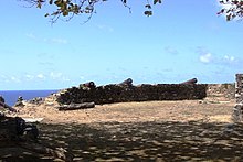
[19][20] When finding out that the French had colonised the island, the Viceroy of Brazil, the Count of Galveias, sent scouts that verified the occupation, on 26 September 1736.
[19] King John V of Portugal determined that the French troops and colonisers were expelled, dispatching a royal charter on 26 May 1737 designating the Governor of Pernambuco, Henrique Luís Pereira Freire de Andrade, to comply with the resolution.
[19] At the same time, the Count of Galveias prepared an expedition with 250 soldiers, commanded by Colonel João Lobo de Lacerda, that sailed from Recife on 6 October 1737.
[19][20] Captain Henry Foster stopped at Fernando de Noronha during his scientific survey expedition as commander of HMS Chanticleer, which had set out in 1828.
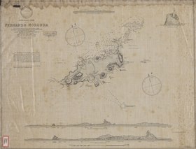
[23] The longitude of Rio de Janeiro taken by Foster was among those on one side of a significant discrepancy, which meant that the charts of South America were in doubt.
One of its essential tasks was a stop at Fernando Noronha to confirm its exact longitude, using the 22 chronometers on board the ship to give the precise time of observations.
On 20 February FizRoy landed a small party to take the observations, despite difficulties caused by heavy surf, then sailed on for Bahia, Brazil that evening.
[33] In 1942, during World War II, the archipelago was made a Federal territory, which included Rocas Atoll and Saint Peter and Paul Rocks.
Although there were problems with coolant temperature on the port wing engines plus difficulties in locating the small archipelago, the crew nursed the Argonaut to a safe landing at Fernando de Noronha, some four hours after their ordeal began.
[35] Nowadays, Fernando de Noronha Airport is served by daily flights from Recife and Natal on the Brazilian coast.
In 1988, Brazil designated approximately 70% of the archipelago as a maritime national park, with the goal of preserving the land and sea environment.
In addition to the historical interest noted above, the archipelago has been the subject of the attention of various scientists dedicated to the study of its flora, fauna, geology, etc.
[citation needed] In 2001, the United Nations Educational, Scientific and Cultural Organization (UNESCO) declared Fernando de Noronha, with Rocas Atoll, a World Heritage Site.
The volcanic rocks are of variable, though mainly silica-undersaturated, character with basanite, nephelinite and phonolite among the lava types found.
Due to the South Equatorial Current that pushes warm water from Africa to the island, diving to depths of 30 to 40 m (98 to 131 ft) does not require a wetsuit.