Fifth principal meridian
The meridian, a north-south line, starts from the old mouth of the Arkansas River and runs north.
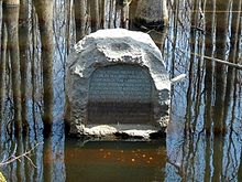
Monuments have been erected where the two lines meet at 34°38′44″N 91°3′42″W / 34.64556°N 91.06167°W / 34.64556; -91.06167, and the surveyors' skill has been commemorated at the Louisiana Purchase State Park in eastern Arkansas.
In Arkansas, Missouri, Iowa, and North Dakota, it is the sole principal meridian used in the PLSS.
As a result the initial point is in the middle of a high water swamp, on land that belonged to the Davidsons of Marvell, Arkansas.
At the terminus of the boardwalk there is a granite monument which reads, "This stone marks the base established Nov. 10, 1815 from which the lands of the Louisiana Purchase were surveyed by United States Engineers, the first survey from this point was made to satisfy the claims of the soldiers of the War of 1812, with land bounties.