Flood control in the Netherlands
Natural sand dunes and constructed dikes, dams, and floodgates provide defense against storm surges from the sea.
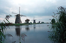
River dikes prevent flooding from water flowing into the country by the major rivers Rhine and Meuse, while a complicated system of drainage ditches, canals, and pumping stations (historically: windmills) keep the low-lying parts dry for habitation and agriculture.
Roman author Pliny, of the 1st century, wrote something similar in his Natural History:[1] There, twice in every twenty-four hours, the ocean's vast tide sweeps in a flood over a large stretch of land and hides Nature's everlasting controversy about whether this region belongs to the land or to the sea.
There these wretched peoples occupy high ground, or manmade platforms constructed above the level of the highest tide they experience; they live in huts built on the site so chosen and are like sailors in ships when the waters cover the surrounding land, but when the tide has receded they are like shipwrecked victims.
It does not fall to their lot to keep herds and live on milk, like neighboring tribes, nor even to fight with wild animals, since all undergrowth has been pushed far back.The flood-threatened area of the Netherlands is essentially an alluvial plain, built up from sediment left by thousands of years of flooding by rivers and the sea.
The coast consisted of a row of coastal dunes and natural embankments which kept the swamps from draining but also from being washed away by the sea.
The only areas suitable for habitation were on the higher grounds in the east and south and on the dunes and natural embankments along the coast and the rivers.
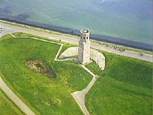
To protect themselves against floods they built their homes on artificial dwelling hills called terpen or wierden (known as Warften or Halligen in Germany).
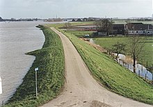
The first dikes were low embankments of only a meter or so in height surrounding fields to protect the crops against occasional flooding.
Compression and rotting processes resulted in a solid residue that proved very effective against wave action and they needed very little maintenance.
Much damage was done to these wood constructions with the arrival of the shipworm (Teredo navalis), a bivalve thought to have been brought to the Netherlands by VOC trading ships, that ate its way through Dutch sea defenses around 1730.
Current dikes are made with a core of sand, covered by a thick layer of clay to provide waterproofing and resistance against erosion.
However, the peat settled much more than other soil types when drained and land subsidence resulted in developed areas becoming wet again.
The mouths of streams and rivers were dammed to prevent high water levels flowing back upstream and overflowing cultivated lands.
These dams had a wooden culvert equipped with a valve, allowing drainage but preventing water from flowing upstream.
The growth of towns and industry in the Middle Ages resulted in an increased demand for dried peat as fuel.
These undertakings often devastated the landscape as agricultural land was dug away and the leftover ridges, used for drying the peat, collapsed under the action of waves.
Drained lakes and new polders can often be easily distinguished on topographic maps by their different regular division pattern as compared to their older surroundings.
Local rulers dammed branches of rivers to prevent flooding on their lands (Graaf van Holland, c. 1160, Kromme Rijn; Floris V, 1285, Hollandse IJssel), only to cause problems to others living further upstream.
Large scale deforestation upstream caused the river levels to become ever more extreme while the demand for arable land led to more land being protected by dikes, giving less space to the river stream bed and so causing even higher water levels.
Land reclamation works, large willow plantations and building in the winter bed of the river all worsened the problem.
Water boards hold separate elections, levy taxes, and function independently from other government bodies.
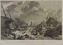
A series of devastating storm surges, more or less starting with the First All Saints' flood (Allerheiligenvloed) in 1170 washed away a large area of peat marshes, enlarging the Wadden Sea and connecting the previously existing Lake Almere in the middle of the country to the North Sea, thereby creating the Zuiderzee.
The system proved successful on the Hollandic Water Line in rampjaar 1672 during the Third Anglo-Dutch War but was overcome in 1795 because of heavy frost.
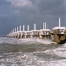
Technological development in the 20th century meant that larger projects could be undertaken to further improve the safety against flooding and to reclaim large areas of land.
Plans to reclaim parts of the Wadden Sea and the Markermeer were eventually called off because of the ecological and recreational values of these waters.
Following the damming, large areas of land were reclaimed in the newly freshwater lake body by means of polders.
A study done by Rijkswaterstaat in 1937 showed that the sea defenses in the southwest river delta were inadequate to withstand a major storm surge.
This, land subsidence, and increased storms make further upgrades to the flood control and water management infrastructure necessary.
[13] Global warming in the 21st century might result in a rise in sea level which could overwhelm the measures the Netherlands has taken to control floods.