Foothills Parkway
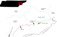
The other open section (8A) is a 5.6-mile (9.0 km) stretch traversing Green Mountain in Cocke county, connecting U.S. 321 in Cosby with I-40 in the Pigeon River valley.
The most prominent of the foothills are characterized by long-but-narrow ridges, running parallel to the crest of the Smokies, similar to a circuit wall surrounding a medieval castle.
Although the average elevation of the foothills is relatively low, a high topographic prominence is not uncommon among these ridges, due to their detachment from the main crest of the Smokies.
Geologically, the foothills largely consist of Cambrian Class III rocks of the Paleozoic period, a type known specifically as the Chilhowee Group.
Although Bates lacks the dramatic "backbone" formation of Chilhowee, a rocky gorge on its south flank cut by Carr Creek has presented numerous construction challenges for the parkway project.
35°43′22″N 83°45′06″W / 35.7227°N 83.75161°W / 35.7227; -83.75161 Cove Mountain — a large ridge situated between Wears Valley to the west, Gatlinburg to the east, and Pigeon Forge to the north.
35°48′44″N 83°12′05″W / 35.8123°N 83.2014°W / 35.8123; -83.2014 English Mountain, the highest of the Foothills at 3,629 feet (1,112m), stretches for nearly 15 miles (24 km) between the East Fork of the Little Pigeon and Newport, paralleling the shores of Douglas Lake.
Resort hotels quickly sprang up throughout the foothills, becoming popular summertime destinations for Knoxville's upper class.
[9] In 1885, Mary Noailles Murfree, one of the first authors to popularize the natural wonders of the Smokies, wrote: ... Chilhowee Mountain, rising up, massive and splendid, against the west.
[12] In 1944, after extensive lobbying by Congressman B. Carroll Reece, Congress authorized construction of a 71-mile (114 km) road connecting US-129 at Chilhowee Lake and I-40 along the Pigeon River.
[12] While the early bureaucratic hurdles had been cleared, the Tennessee Highway Department moved slowly in purchasing the road's rights-of-way.
[12] The original plan for Foothills Parkway called for eight sections: After the initial progress in the 1960s, the project again stalled in the 1970s due to funding cuts.
Construction on the two sections between Walland and Wears Valley finally began in 1984, but after some progress, was halted due to erosion and other environmental issues, specifically the spilling of sulfuric acid into nearby streams.
Although no funding has been set aside for the remaining sections of the parkway between Wears Valley and Cosby, the NPS still owns the rights-of-way, and their completion has not been ruled out.
In early 2007, the National Park Service began conducting an environmental impact assessment and collecting public input regarding section 8B (Pittman Center to Cosby).
To the southwest, the Yellow Creek section of the Unicoi Mountains is visible, along with a dramatic view of Chilhowee's western ridgeline.
From the northeast section, English Mountain presents as a large ridge to the northwest, and Hall Top rises in peak-like fashion to the east.