Fort Ross, California
The present name of Fort Ross[5] appears first on a French chart published in 1842 by Eugène Duflot de Mofras, who visited California in 1840.
By that time, British and American fur trade companies had also established a coastal presence, in the Pacific Northwest, and Mexico was soon to gain independence.
Archaeological data shows that the Kashaya Pomo increased their subsistence activities upon arrival at this site and gained greater diversity in their tool kits.
Subsequent reports by the Russian hunting parties of uncolonized stretches of coast encouraged Baranov, the Chief Administrator of the Russian-American Company (RAC), to consider a settlement in California north of the limit of Spanish occupation in San Francisco.
While guests of the Spanish, Rezanov's captain, Lt. Khvostov, explored and charted the coast north of San Francisco Bay and found it completely unoccupied by other European powers.
Kuskov, on the Kad'yak, was instructed to bury the plaques, with an appropriate possession ceremony, at Trinidad, Bodega Bay, and on the shore north of San Francisco, indicating Russian claims to the land.
After exploring the area they ended up selecting a place 15 miles (24 km) north that the native Kashaya Pomo people called Mad shui nui or Metini.
[16] These settlements constituted the southernmost Russian colony in North America and were spread over an area stretching from Point Arena to Tomales Bay.
In addition to farming and manufacturing, the Company carried on its fur-trading business at Fort Ross, but by 1817, after 20 years of intense hunting by Spanish, American and British ships—followed by Russian efforts—sea otters had been practically eliminated from the area.
The native populations of the Sonoma and Napa County regions were affected by smallpox, measles and other infectious diseases that were common across Asia, Europe, and Africa.
Another instance of disease prevention was when a visiting Hudson's Bay Company hunting party was refused entry to the Colony in 1833, when it was feared that a malaria epidemic which had devastated the Central Valley was carried by its members.
[20] Between 1824 and 1836 the Mexicans found during every exploratory effort north of present-day San Rafael and west of Sonoma increasing evidence of Russian presence.
To extend the settlements in the direction of Fort Ross, Vallejo granted his brother-in-law, Captain John B. R. Cooper, who had married his sister Encarnacion, Rancho El Molino (about 17,892-acre (72.41 km2)).
Alvarado saw Sutter's plan of establishing a colony in the Central Valley as useful in "buttressing the frontier which he was trying to maintain against Indians, Russians, Americans and British.
"[23] Sutter persuaded Governor Alvarado to grant him 48,400 acres (19,600 ha) of land for the sake of curtailing American encroachment on the Mexican territory of California.
Sutter was given the right to "represent in the Establishment of New Helvetia all the laws of the country, to function as political authority and dispenser of justice, in order to prevent the robberies committed by adventurers from the United States, to stop the invasion of savage Indians, and the hunting and trading by companies from the Columbia (river)."
[24] In an 1841 inventory for John Sutter describes the settlement surrounding the fort: "twenty-four planked dwellings with glazed windows, a floor and a ceiling; each had a garden.
The Russian-American Company consequently offered the settlement to various potential purchasers, and in 1841 it was sold to John Sutter, a Mexican citizen of Swiss origin, soon to be renowned for the discovery of gold at his lumber mill in the Sacramento valley.
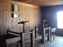
The Fort Ross Chapel collapsed in the 1906 San Francisco earthquake but much of the original structural woodwork remained and it was re-erected in 1916, but retained the appearance of the American ranch-period modifications when it was used as a stable.
[27] "The Fort Ross Chapel was found eligible for designation as a National Historic Landmark in 1969, architecturally significant as a rare U.S. example of a log church constructed on a Russian quadrilateral plan.
A large orchard, including several original trees planted by the Russians, is located inland on Fort Ross Road in Sonoma County.
[34] In consultation with Reverend Vladimir Derugin of the ROC, researchers were able to confirm that the burial practices followed traditional Russian Orthodox canon and norms, despite having been conducted in a remote frontier outpost.
Fort Ross is owned by the state of California and is operated by the department of parks and recreation, so they had to give permission in order for the excavation to occur.
For instance, the Russians thought that everyone buried in the cemetery, including the Kashaya and Alaskan natives, were a part of the Orthodox religion, meaning they had converted.
[38] Based on the descriptions given by people who visited Fort Ross, it has been concluded that the main windmill, located outside the blockade, was the traditional style Russian stolbovki.
The purpose was to "examine the nature, extent, and direction of cultural change among native workers in a pluralistic, hierarchically structured, mercantile colony."
"[41] The aforementioned surface collection resulted in the discovery of "glass beads, ceramics, projectile points, flakes, and worked bone artifacts over a 200 x 40 m area.
A redwood fence line outside the South Pit feature was also discovered, as well as several contextually rich deposits which contained dense concentrations of faunal elements and artifacts, with two in particular being found in the field seasons of 1992 and 1993.
[41] The Fort Ross Beach site saw subsurface testing which led to the discovery of a wide range of faunal remains from domesticated, terrestrial, and sea mammals to fish, birds, and shells of several organisms.
[49] Fort Ross is located on the coast, meaning it is vulnerable to erosion and other natural processes, such as acidic soil, wildfires, and even the destruction of animals like gophers.