Fort Tryon Park
Fort Tryon Park was added to the National Register of Historic Places on December 19, 1978 and was designated a New York City scenic landmark in 1983.
It is bounded on the west by the Henry Hudson Parkway, on the north by Riverside Drive, on the east by Broadway and Bennett Avenue, and on the south by the alignment of 192nd Street.
A small section at the park's southwestern corner is located between Cabrini Boulevard to the east and Henry Hudson Parkway to the west, and is bounded to the south by 190th Street.
[12][13] In precolonial times, a Native American road ran within this valley from the present-day intersection of Broadway and Dyckman Street to a settlement on the Hudson River.
[12][18] The northern portion of Manhattan was first known to be inhabited by the Wecquaesgeek tribe of Lenape Native Americans,[19][20][21][22] who referred to the area around Fort Tryon Park as Chquaesgeck.
[9] When Dutch settlers inhabited the lower Hudson Valley in the early 17th century, they attempted to force the Native Americans out, and some of the Wecquaesgeeks continued to occupy the area.
[19][28] The park was an ancillary site of the Battle of Fort Washington, fought on November 16, 1776, between 2,900 American soldiers and 8,000 invading Hessian troops hired by Great Britain.
[19] American soldier Margaret Corbin became the first woman to fight in the war and was injured during the battle; the southern entrance to the park bears her name.
[19] As New York City expanded and prospered following the end of the Revolutionary War, the land comprising the park remained undeveloped, except for a few country estates.
Part of the estate was sold in 1855 to August C. Richards, who built a Gothic-style stone castle called "Woodcliff", designed by Alexander Jackson Davis.
[26] Woodcliff was subsequently used as a summer home by General Daniel Butterfield, Boss Tweed, Alexander Turney Stewart, and William Libbey, whereupon it became known as "Libby Castle".
[31][32][33] Another portion of the Chittenden site was developed by William C. Muschenheim, later an operator of the Hotel Astor, who built an estate called "Fort Tryon Terrace".
On the site, he built "Tryon Hall", a Châteauesque-style mansion with a swimming pool, horse stables, a formal garden, pergolas, and a winding 2,000-foot-long (610 m) driveway leading from Riverside Drive.
[31][32][33] Immediately to the north were Abbey Inn, a summer residence built on land that Willam Henry Hays had purchased in 1842, and another estate that Walter S. Sheafer, the state geologist of Pennsylvania, had bought in 1891.
[9] The work included numerous smaller projects such as destruction of the old Billings estate; grading of the terrain; constructing structures such as arches and balconies; planting trees, shrubs, and lawns; and cutting into the ridge of the west side of the park to create an extension of Riverside Drive.
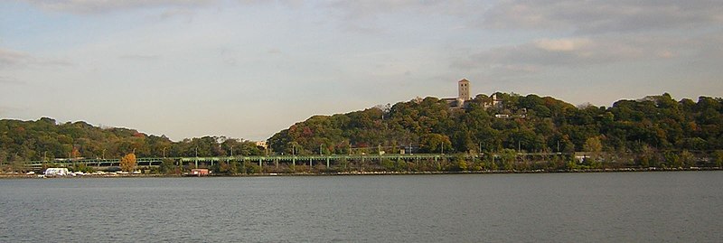
In 1936, the Met gave the city a small portion of the land intended for the Cloisters, thereby increasing Fort Tryon Park's area slightly.
His efforts led Hope Irvine, a co-chairperson of Manhattan Community Board 12's Bicentennial Committee, to suggest Margaret Corbin's name for the park.
[106] Olmsted Jr. believed that the park should use a variety of landscapes: Each unit in this intricate series of places should offer a picture of as great perfection as can be contrived, using the same great distant views over the Hudson and over the City gain and again but framing them differently, presenting them with constantly differing types of foreground, some intricate and intimate, some grandiose and simple, some richly architectural or gardenesque, some picturesquely naturalistic; and, by way of contrast, some presenting wholly self-contained scenes.
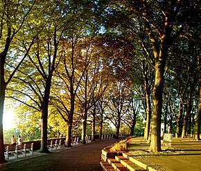
Other deviations from past designs included the emphasis of Heather Garden, a gardenesque feature, as well as the formally-designed children's playground at the northeast corner.
[107] Formally designated in 1977,[76][77][78] the name commemorates the Continental Army soldier in the American Revolutionary War who was wounded in the Battle of Fort Washington.
[26][28][30] A secondary roadway named Fort Tryon Place carries traffic to and from the northbound lanes of Henry Hudson Parkway, at the bottom of the cliff to the west.
Olmsted Brothers transported 180 fully grown "mature trees" and planted more than 1,600 floral species to make the park appear like a botanical garden.
[112] The Alpine Garden, the other formal space planned by the Olmsted Brothers, is located on the ridge along the park's eastern side, to the east of the Cloisters.
The park's northeast corner contains the Anne Loftus Playground, a triangle-shaped play area that primarily serves the Inwood neighborhood to the north.
[127] The museum is surrounded by the circular park drive, and its site is bounded by many plantings including an apple orchard to the south and denser vegetation to the north and west.
[132] However, Linden Terrace is not the island's highest natural point, which is located within Bennett Park a few blocks south, 265 feet (81 m) above sea level.
[142][143] The Shelter Overlook, an octagonal gazebo, is located east of Corbin Drive at the northeast corner of Sir William's Dog Run.
[79] The New York City Subway's IND Eighth Avenue Line (A train) runs directly underneath Fort Tryon Park.
[154] On the other hand, Fort Tryon Park has historically been used as a location for sexual intercourse due to this seclusion, and in some years, New York City Police Department officers would issue summons once a week.
[155] The Fort Tryon Park Trust helps fund programs for all ages like yoga and tai chi classes, live outdoor concerts, and bird walks.