Fortifications of Larrun
The mountain reaches an elevation of 905 meters, with its summit and slopes divided between four communes: Vera de Bidassoa in Spain and Ascain, Sare, and Urrugne in France.
[JL 2] This configuration was particularly evident when the Allies captured the Hermitage redoubt at the summit of Larrun, resulting in the fortified Alchangue ridge becoming subject to their artillery fire.
[UR 2] The opposing forces included 8,000 French soldiers, positioned by General Servan—who served as War Minister until his resignation on October 3, 1792[3]—in the communes of Sare, Hendaye, and Urrugne.
[Note 1] They were opposed by 2,200 Spaniards under the command of General Ventura Caro, who had been reinforced by the army of émigrés led by the Marquis of Saint-Simon.
Finally, the Bidassoa estuary required the establishment or reinforcement of the Sans-Culottes, Ihartzecoborda, and Etsail redoubts from Croix des Bouquets, as well as the digging of trenches to protect the village of Hendaye from the Socorri hill.
[SA 1] On May 2, another Spanish attack on Hendaye was repelled beyond the Bidassoa by French troops, with La Tour d'Auvergne distinguishing himself by his courageous conduct.
In response, the French headquarters withdrew to a position north of the Nivelle River, where they reinforced their troops with recruits who had undergone training at a camp in Bidart until early 1794.
"[GL 1] Marshal Soult, in command of the French forces, had partially fortified the heights and approaches to the Bidassoa but appeared more preoccupied with the fate of Pamplona, which had been under siege by General Enrique José O'Donnell's Spanish troops since June 26.
The center was held by Clauzel's three divisions, led by Taupin, Maransin, and Conroux,[Note 3] which were responsible for guarding the heights of Larrun, Sare, and Ascain.
They crossed the Bidassoa at three distinct fords upstream of Fontarabie,[Note 5] whereas Soult anticipated that the primary assault would occur in the Ainhoa region, situated to the east of Sare.
On the night of October 12-13, the French troops under the command of Conroux recaptured the Santa Barbara redoubt, maintaining control of the position despite a Spanish assault that resulted in the loss of 500 men for the opposing forces.
[S140 1] The front stabilized, and a tacit peace emerged, leading the French and English to neutralize certain areas on the southern slope of Petite Larrun.
[Note 11] At dawn, the Allied forces, under the command of General Colville,[S141 1] successfully captured the Santa-Barbara and Grenada redoubts and initiated an offensive against the Alchangue positions.
[GL 6] The Allied divisions under the command of Generals Le Cor, Cole, Alten, Longa, and Freyre were able to gain the upper hand over the French defenders.
[GL 6][Note 14] By the end of November 10, the French army remained deployed to the east, supported by the Nive and Larressore under the command of Drouet d'Erlon.
Its center was situated near Bayonne on the Saint-Pée road, while to the west, it occupied the Nivelle Valley from Saint-Jean-de-Luz to Serres under the command of Reille.
[AB 7]From the top of Rhune, observe the long line of summits crowned by redoubts; see on their slopes the short and modest linéaments of trenches, too spaced to support each other; place our unfortunate divisions in their positions; follow the march of the enemy columns winding from height to valley up to the slopes of the Atome barrier, ascending, preceded by a swarm of skirmishers that blinds the defense and overwhelms the redoubts, and you will recognize that no human genius could have saved us from disaster.
[JL 6]The redoubts of Biskarzoun and Esnaur are situated on two mounds overlooking Ascain, affording observation of potential attackers' approach from all directions.
[S141 4] Although isolated from the remainder of the position and still incomplete at dawn on November 10, 1813, the redoubts were sufficiently substantial to withstand a direct attack due to their location.
[5] The Esnaur Redoubt is situated at an altitude of 273 meters and serves as a dominant defensive position along the route leading to the Saint-Ignace pass [fr].
[8] Although the redoubt is situated within the boundaries of Sare, the western extremity of the Alchangue ridge, colloquially designated Petite Larrun by military authorities, is depicted on the Ascain cadastre.
[2] The redoubt, constructed using superimposed sandstone slabs without the addition of cement, exhibits a six-pointed star shape, rendering it particularly suited for short-range flanking fire.
[GL 10] The French defenders engaged in a desperate battle, utilizing their remaining ammunition and strength, and resorting to the use of stones and rocks during the Allies' final assault.
[JA 1] On November 10, 1813, the front formed by the redoubt of the Chapel of La Madeleine and that of Louis XIV was overrun following two unsuccessful assaults by two Anglo-Portuguese divisions.
[GL 15] During the 1813 battles, the redoubt offered significant resistance to Allied troops; however, it ultimately succumbed to the combined assault of a British horse battery and a Portuguese infantry brigade.
[GL 11] Similarly, the redoubt of boundary marker 29, also designated as Bechini, is situated on a plateau at an elevation of 600 meters, at the base of the Larrun summit.
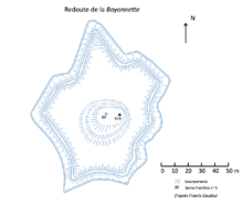
Its protection was ensured by a ditch and a parapet […][SA 6]The elliptical shape is a relatively uncommon feature among modern-era fortifications, which may be attributed to the protohistoric origins of the structure in question.
Its plan, with a very irregular polygonal shape, closely follows the terrain's relief to provide defenders with the best possibilities for shooting and flanking [...][UR 7]The parapet surrounding the structure measures 350 meters in length.
It acquired its designation as the "Bayonnette Redoubt" as a result of the French bayonet charge against the Spaniards, which commenced on July 24, 1794,[UR 8] intending to reclaim the position that had been lost on May 2, 1793.
[18] General Van der Maësen, who died while trying to clear the bridge at Vera de Bidassoa, was temporarily buried there before being subsequently interred at the Ascain cemetery.

| The Larrun defense system (a reference in bold type indicates an MH listing by the French Ministry of Culture). | |
|---|---|
| 1. Louis XIV Redoubt. | 12. Olhain chapel redoubt. |
| 2. Bortuste Redoubt. | 13. Mendibidea Redoubt. |
| 3. Bayonnette Redoubt. | 14. Ermebaita Redoubt. |
| 4. Emigrés Redoubt. | 15. Monhoa Redoubt. |
| 5. Ihicelhaya fortress. | 16. Grenada Redoubt. |
| 6. Hermitage Redoubt. | 17. Zuhalmendi Redoubt. |
| 7. BF 29 Redoubt. | 18. Santa-Barbara Redoubt. |
| 8. Mouiz camp. | 19. Louis XIV Redoubt. |
| 9. Idoyko Biskarra Redoubt. | 20. Madeleine chapel Redoubt. |
| 10. Esnaur Redoubt. | |
| 11. Bizkarzoun Redoubt. | |