Frutigen
Frutigen is a municipality in the Bernese Oberland area of the Swiss canton of Bern.
[3] The area around Frutigen may have been settled since possibly the Bronze Age or Roman Empire times.
[4] During the Middle Ages there were three castles in the modern municipal border; Halten, Tellenburg and Bürg.
By 1260 the scattered farmers of the valley floor had formed a political and business association.
The residents of the valley were freed from the obligation to pay taxes or provide labor for local lords and their soldiers marched under their own banner.
Frutigen, like the rest of the Bernese Oberland, resisted the new faith, but adopted it after the Interlaken uprising was suppressed.
The large parish of Frutigen was divided several times but still includes the villages of Schwandi and Wengi which are both part of the municipality of Reichenbach.
A sust or warehouse and mountain pass way station was built in Kanderbrück in the 16th century, though similar buildings existed since at least the Middle Ages.
The railroad and improved roads allowed industry and tourism to flourish in the municipality.
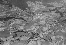
[6] The municipality includes parts of the Kander and Engstligen valleys between the Niesenkette and Gehrihorn.
It includes the villages of Frutigen, Kanderbrück, Hasli, Innerschwandi, Ladholz, Oberfeld-Prasten, Reinisch and Winklen mit Weilern as well as individual farms on the valley floor and stretching up the mountain sides to 1,600 m (5,200 ft) above sea level.
[7] The blazon of the municipal coat of arms is Argent an Eagle displayed Sable crowned, beaked, langued and membered Or.
[11] Most of the population (as of 2000[update]) speaks German (6,403 or 96.1%) as their first language, Albanian is the second most common (63 or 0.9%) and French is the third (35 or 0.5%).
The historical population is given in the following chart:[4][14] The entire hamlet of Kanderbrück and the Rybrügg / Hasli area are part of the Inventory of Swiss Heritage Sites.
[16] Today the main focus of its economy is the hydraulics industry, slate mining and tourism.
The number of jobs in the primary sector was 361, of which 357 were in agriculture, 1 was in forestry or lumber production and 3 were in fishing or fisheries.
In the tertiary sector; 280 or 22.3% were in wholesale or retail sales or the repair of motor vehicles, 206 or 16.4% were in the movement and storage of goods, 92 or 7.3% were in a hotel or restaurant, 18 or 1.4% were in the information industry, 74 or 5.9% were the insurance or financial industry, 96 or 7.7% were technical professionals or scientists, 90 or 7.2% were in education and 280 or 22.3% were in health care.
The municipality is also served by PostAuto bus services from the railway station to Wengi, Reudlen and Reichenbach im Kandertal, to Kandergrund, Blausee, Mitholz and Kandersteg, and to Achseten and Adelboden.
[3][19][20][21] From the 2000 census[update], 397 or 6.0% were Roman Catholic, while 4,586 or 68.8% belonged to the Swiss Reformed Church.
The wettest month was July during which time Frutigen received an average of 148 mm (5.8 in) of rain or snow.
The month with the most days of precipitation was June, with an average of 14.1, but with only 138 mm (5.4 in) of rain or snow.
This is followed by three years of obligatory lower Secondary school where the students are separated according to ability and aptitude.
Following the lower Secondary students may attend additional schooling or they may enter an apprenticeship.