Vulkathunha-Gammon Ranges National Park
The Gammons are dominated by "The Plateau" in the southwest, which is contiguous with and of much the same height as the Blue Range further northeast, culminating in Benbonyathe Hill (1064m), the highest point in the Flinders north of Wilpena.
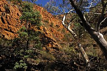
Of these "rounded hills" of the plateau, Warren Bonython writes that "at their edge the slope, which was gentle near the crest, progressively steepens and then changes dramatically into a precipice plunging down to a rock-strewn creek bed perhaps a thousand feet below"[2] Some of the features of the ranges are the deep gorges cut in the south-eastern side of the Blue Range: Bunyip Chasm, The Terraces, and Fern Chasm are all areas often visited by bushwalkers.
Also included in the national park is a wide strip of territory running 40 km from the edge of the ranges to the shores of Lake Frome, an area which is used by the local Aboriginal people for hunting kangaroos and emus.
Attempting to find a way through the salt lakes that he thought barred the path to the north, he climbed Mount Serle; in his published expedition journal, he wrote that "to the north-east, the view was obstructed by a high range immediately in front of us".
The next explorer to reach the area was the Surveyor General, Edward Charles Frome, on his second expedition up the eastern side of the Flinders three years later.
The bushman R. M. Williams is reputed to have learnt everything he knew about boot-making and leather from another man he met while camped in Italowie Gap at the southern end of the ranges; he later became a millionaire and a renowned clothing brand carries his name.
On Bonython's first journey onto the Blue Range in 1946 several kilometres south of Benbonyathe Hill, one of his two companions, Bob Crocker, slipped and broke his leg, which resulted in Bonython walking more than twenty kilometres to Balcanoona station to organise a rescue effort: in the end Bob was carried off the 3,000-foot (910 m) high range by improvised stretcher in a seven-hour marathon.
A historic former mining site, the Bolla Bollana Brick Kiln and Copper Smelter Ruins, lies within the national park and is listed on the South Australian Heritage Register.
The Copley-Arkaroola dirt road (passable to 2WD vehicles) passes through Italowie Gap at the southern edge of the national park, from where it is a one-day walk north to Mount McKinlay.
Access to the northern side of the national park is even more difficult, with the 4WD track to the bordering pastoral station of Yankaninna providing the closest road.
[5] One problem plaguing the national park (as with all the Flinders) is feral goats, which are capable of traversing the rugged stony terrain, and which, thanks to the lack of predators, flourish.
The population in the national park has been reduced by means of hunters staking out waterholes and helicopters picking off animals on the ridge-tops: the help of the local sporting shooters' association has been employed in managing the problem.
Large-scale baiting programs carried out as part of Operation Bounceback have reduced the number of foxes in the national park.