Garonne
The Garonne's headwaters are to be found in the Aran Valley in the Spanish Pyrenees, though three different locations have been proposed as the true source: the Uelh deth Garona at Plan de Beret (42°42′34″N 0°56′43″E / 42.709494°N 0.945398°E / 42.709494; 0.945398), the Ratera-Saboredo cirque 42°36′26″N 0°57′56″E / 42.607295°N 0.965424°E / 42.607295; 0.965424), or the slopes of Pic Aneto (Salterillo-Barrancs ravine 42°38′59″N 0°40′06″E / 42.6498°N 0.6683°E / 42.6498; 0.6683 according to the season).
From this point a brook (called the Beret-Garona) runs for 2.5 kilometres (1.6 mi) to the bed of the main upper Garonne valley.
[7][8][9][10] The third theory holds that the river rises on the slopes of Pic Aneto at 2,300 metres (7,500 ft) above sea level and flows by way of a sinkhole known as the Forau de Aigualluts (42°40′00″N 0°40′01″E / 42.6666°N 0.6669°E / 42.6666; 0.6669) through the limestone of the Tuca Blanca de Pomèro and a resurgence in the Val dera Artiga above the Aran Valley in the Spanish Pyrenees.
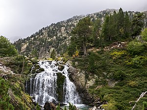
[11] This underground route was suggested by the geologist Ramond de Carbonnières in 1787 but there was no confirmation until 1931, when caver Norbert Casteret poured fluorescein dye into the flow and noted its emergence a few hours later 4 kilometres (2.5 mi) away at Uelhs deth Joèu ("Jove's eyes" 42°40′51″N 0°42′28″E / 42.68092°N 0.7077°E / 42.68092; 0.7077) in the Artiga de Lin on the other side of the mountain.
[5][6][15] Despite the lack of universal agreement on definition for determining a stream's source, the United States Geological Survey, the National Geographic Society and the Smithsonian Institution agree that a stream's source should be considered as the most distant point (along watercourses from the river mouth) in the drainage basin from which water runs.
The Garonne follows the Aran Valley northwards into France, flowing via Toulouse and Agen towards Bordeaux, where it meets the Gironde estuary.
Just after Bordeaux, the Garonne meets the Dordogne at the Bec d'Ambès, forming the Gironde estuary, which after approximately 100 kilometres (62 mi) empties into the Atlantic Ocean.
The river not only allows seagoing vessels to reach the port of Bordeaux but also forms part of the Canal des Deux Mers, linking the Mediterranean Sea and the Atlantic Ocean.
Ships continue on the tidal river Garonne up to the Pont de Pierre (stone bridge) in Bordeaux.
The study aims to inform stakeholders and devise an adaptation strategy within the local master plan of water management and development (SDAGE), considering the impact of the predicted demographic shifts.
Detailed insights into changes in irrigated agricultural areas, crop rotation, and farm numbers are essential for informing effective water management strategies.