Geotagged photograph
Usually this is done by assigning at least a latitude and longitude to the image, and optionally elevation, compass bearing and other fields may also be included.
In theory, every part of a picture can be tied to a geographic location, but in the most typical application, only the position of the photographer is associated with the entire digital image.
Canon uses the USB socket on the wireless file transmitter unit (WFT) as the GPS interface.
The information can be entered by directly giving the coordinates or by selecting a location from a map using software tools.
Manual geotagging also introduces possibilities of error, where a photograph's location is incorrectly represented by wrong coordinates.
These instruments are commonly used in military applications when an aircraft or operator is targeting an area, the position is inaccessible (for example over a valley or wetland), there are personal health & safety concerns (motorway traffic), or the user wants to quickly capture multiple targets from a single, safe position (trees, street signage and furniture).
Civilian integrated GPS cameras with rangefinders and remote standoff capability are currently available made by manufacturers such as Ricoh and Surveylab.
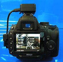
Geotagged photos may be visually stamped with their GPS location information using software tools.
These data are not visible in the picture itself but are read and written by special programs and most digital cameras and modern scanners.
Here is a hexadecimal dump of the relevant section of the Exif metadata (with big-endian byte order):