Geography of Galicia
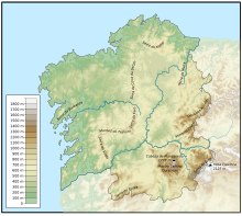
The geography of Galicia (Spain) is characterized by the contrast between the low altitude coastal relief and, further inland, by the higher altitude of the Galician Massif which itself offers contrasts between the morphology of the high northern plains and the southern mountains and valleys.
The territory of Galicia is between 43°47′ N (Estaca de Bares) and 41°49′ N (Portela do Home, border with Portugal) in latitude.
In longitude, the territory lies between 6º42′ W and 9º18′ W. The Galician coast has 1,500 kilometres (930 mi) and has many incoming and outgoing and small islands, and in general is steep declines or little soft.
Alternate locations with different characteristics, as in the Rías Baixas' Corrubedo or the Cantabrian Mariña de Lugo.
The first features a coastal dune in a low profile, and the second a high geological deposition zone on its original level.