Geography of Kazakhstan
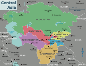
[1] With an area of about 2,724,900 square kilometers (1,052,100 sq mi) Kazakhstan is more than twice the combined size of the other four Central Asian states and 60% larger than Alaska.
Many of the peaks of the Altay and Tien Shan ranges are covered with snow, year-round, and their runoff is the source for most of Kazakhstan's freshwater rivers, streams, and lakes.
They either flow into isolated bodies of water such as the Caspian Sea or simply disappear into the steppes and deserts of central and southern Kazakhstan.
Despite the nation's relatively low precipitation rates and mostly arid geography, spring floods brought on by occasional heavy rainfall and snowmelt are not unusual in the northern and central regions of the country.
In April 2017, following a winter with snow volumes 60 percent above average, heavy rains resulted in widespread damage and temporarily displaced thousands of people.
Experts estimate that if current rates of increase persist, the coastal city of Atyrau, eighty-eight other population centers, and many of Kazakhstan's Caspian oil fields could be submerged soon.
The gravest environmental threat to Kazakhstan comes from radiation, especially in the Semey (Semipalatinsk) region of the northeast, where the Soviet Union tested almost 500 nuclear weapons, 116 of them above ground.
Although nuclear testing was halted in 1990, radiation poisoning, birth defects, severe anemia, and leukemia are thought to be very common in the area.
In February 1989, opposition to Soviet nuclear testing and its ill effects in Kazakhstan led to the creation of one of the republic's largest and most influential grass-roots movements, Nevada-Semipalatinsk, which was founded by Kazak poet and public figure Olzhas Suleymenov.
In the first week of the movement's existence, Nevada-Semipalatinsk gathered more than two million signatures from Kazakhstanis of all ethnic groups on a petition to Mikhail Gorbachev demanding the end of nuclear testing in Kazakhstan.
In 1994 the World Bank, the International Monetary Fund (IMF), and the United States Environmental Protection Agency agreed to give Kazakhstan $62 million to help the country overcome ecological problems.