Geography of Sweden
It borders Norway to the west (which is one of Sweden’s non-EU neighbours); Finland to the northeast; and the Baltic Sea and Gulf of Bothnia to the south and east.
Sweden has a 3,218 km (2,000 mi) long coastline on its east, and the Scandinavian mountain chain (Skanderna) on its western border, separating it from Norway.
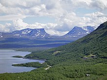
Most of northern and western central Sweden consists of vast tracts of hilly and mountainous land called the Norrland terrain.
[5] From the south the transition to the Norrland terrain is not only seen in the relief but also in the wide and contiguous boreal forests that extend north of it[6] with till and peat being the overwhelmingly most common soil types.
[7] South of the Norrland terrain lies the Central Swedish lowland which forms a broad east-west trending belt from Gothenburg to Stockholm.
[9] The region forms a belt of fertile soils suitable for agriculture that interrupts the forested and till-coated lands to the north and south.
[10] Before the expansion of agriculture, these fertile soils were covered by a broad-leaved tree forest where maples, oaks, ashes, small-leaved lime and common hazel grew.
They differ from the rest of Sweden by being made up of limestone and marl with an alvar vegetation adapted to the island's calcareous soils.
These include active cliffs seen in segments of their western coasts,[20] sea stacks called rauks and large cave systems.
Sweden has 25 provinces or landskap ("landscapes"), based on culture, geography and history: Bohuslän, Blekinge, Dalarna, Dalsland, Gotland, Gästrikland, Halland, Hälsingland, Härjedalen, Jämtland, Lapland, Medelpad, Norrbotten, Närke, Skåne, Småland, Södermanland, Uppland, Värmland, Västmanland, Västerbotten, Västergötland, Ångermanland, Öland and Östergötland.
[21] The mountainous north is considerably less populated than the southern and central regions, partly because the summer period lasts longer in the south, and this is where the more successful agricultural industries were originally established.
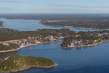
[22] Cities and towns in Sweden are neither political nor administrative entities; rather they are localities or urban areas, independent of municipal subdivisions.
Sweden's natural resources include copper, gold, hydropower, iron ore, lead, silver, timber, uranium, and zinc.
The warmest summers usually happen in the Mälaren Valley around Stockholm[23] due to the vast landmass shielding the middle east coast from Atlantic low-pressure systems in July compared to the south and west.
[24] Sweden is much warmer and drier than other places at a similar latitude, and even somewhat farther south, mainly because of the combination of the Gulf Stream[25][26] and the general west wind drift, caused by the direction of planet Earth's rotation.
Continental west-coasts (to which all of Scandinavia belongs, as the westernmost part of the Eurasian continent), are notably warmer than continental east-coasts; this can also be seen by comparing e.g. the Canadian cities of Vancouver and Halifax, Nova Scotia with each other, the winter in west coast Vancouver is much milder; also, for example, central and southern Sweden has much milder winters than many parts of Russia, Canada, and the northern United States.
That, in turn, renders most of Sweden's southern areas having warmer summers than almost everywhere in the nearby British Isles, even matching temperatures found along the continental Atlantic coast as far south as in northern Spain.
This is due to the south's being surrounded by a greater mass of water, with the wider Baltic Sea and the Atlantic air passing over lowland areas from the south-west.
When hot continental air hits the country, the long days and short nights frequently bring temperatures up to 30 °C (86 °F) or above even in coastal areas.
Coastal areas can see so-called tropical nights above 20 °C (68 °F) occur due to the moderating sea influence during warmer summers.
Transitional seasons are normally quite extensive and the four-season climate applies to most of Sweden's territory, except in Scania where some years do not record a meteorological winter (see table below) or in the high Lapland mountains where polar microclimates exist.
It is predicted that as the Barents Sea gets less frozen in the coming winters, becoming thus "Atlantified", additional evaporation will increase future snowfalls in Sweden and much of continental Europe.
[34] Swedish Meteorological Institute, SMHI's monthly average temperatures of some of their weather stations – for the latest scientific full prefixed thirty-year period 1961–1990 Next will be presented in year 2020.
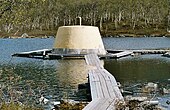
[41] Sweden's southernmost point is in the harbour of the fishing village Smygehuk, near the city of Trelleborg,[42] which borders the Baltic Sea.
[43] At the pier of the harbour, a signpost displays the exact position of the point, as well as the distance to Treriksröset, Stockholm, Berlin, Paris, and Moscow.


people/km 2