Geology of Iceland
The plume is believed to have caused the formation of Iceland itself, the island first appearing over the ocean surface about 16 to 18 million years ago.
The eruption of Laki in 1783 caused much devastation and loss of life, leading to a famine that killed about 25% of the island's population[3] and resulted in a drop in global temperatures, as sulfur dioxide was spewed into the Northern Hemisphere.
Some scientists believe the hotspot beneath Iceland could have contributed to the rifting of the supercontinent Pangaea and the subsequent formation of the North Atlantic Ocean.
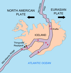
Igneous rocks which arose from this hotspot have been found on both sides of the Mid-Atlantic Ridge, which originated 57–53 million years ago ("Ma"), around the time North America and Eurasia separated and sea floor spreading began in the Northeast Atlantic.
[5] Geologists can determine plate motion relative to the Icelandic hotspot by examining igneous rocks throughout the Northern Atlantic region.
As the North Atlantic Ocean continued to spread apart, Greenland was located to the southeast of the Iceland hotspot and likely moved over it 70–40 Ma.
If this is true, then much of the rifting in the North Atlantic was likely caused by thinning and bulging of the crust as opposed to the more direct influence of the mantle plume which sustains the Iceland hotspot.
[10] As it is one of the only places where sea floor spreading can be observed on land, and where there is evidence for a mantle plume, the geological history of Iceland will likely remain a popular area of research.
[12] The offset between the WVZ and the EVZ is accommodated by the South Iceland seismic zone, an area characterized by high earthquake activity.
After the eruption of the Fagradalsfjall volcano on 19 March 2021, National Geographic's experts predicted that this "may mark the start of decades of volcanic activity".
[14] There was a fissure eruption adjacent to the summit of Litli-Hrútur in July 2023,[15] followed in October 2023 with earthquake unrest that lead to the evacuation of the town of Grindavik.
[16] The history of glaciation on Iceland began 3.3 million years ago, marking a dramatic change in environmental conditions.
[19] As many glaciers overlie active volcanoes, subglacial eruptions can pose hazards due to sudden floods produced by glacial meltwater, known as jökulhlaup.
In the case of Iceland, this type of eruption is the cause of massive plumes of volcanic ash that migrate to Europe and disrupt air traffic.
[20] Historically these explosive eruptions have had other impacts on human civilization as well, including acid rain and significant changes in weather patterns.
While mechanisms are still poorly understood, surge frequency could be related to climate cycles, basal hydrology, volcanic eruptions and jökulhlaups.
In Iceland there is a high rate of seismicity, with most earthquakes being recorded at or near these zones, correlated with active volcanoes and motion of the spreading boundary, often expressed as system of transform faults.
Extended periods of monitoring suggest that the rate of vertical motion of Iceland is increasing, as glaciers continue to be depleted.
One way scientists measure the island's movements and changes is through a permanent network of continuous Global Positioning System (GPS) stations.
[28] The country's woodlands and forests have been exploited for fuel and timber and as settlements grew, livestock populations increased and agriculture expanded.
[27] Its lack of vegetation cover has left the soil more vulnerable to weathering and natural catastrophe events, such as volcanic activity and landslides.