Geology of the Alps
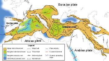
The Alps arose as a result of the collision of the African and Eurasian tectonic plates, in which the Alpine Tethys, which was formerly in between these continents, disappeared.
Subsequently, the formation of the Mediterranean Sea covered terranes originating within the African plate south of the mountains.
In the northeast, southward dipping and internally thrust Cenozoic foreland deposits (flysch and molasse) are found.
In Switzerland the Molasse Basin is rimmed to the northwest by the Jura Mountains, an external fold-and-thrust belt, which can be seen as part of the Alps geologically.
The western part of the Molasse basin forms the plateau of the Mittelland between the Alps and Jura Mountains.
The Alps continue fairly smoothly into the following related Alpine mountain ranges: the Apennines to the southwest, the Dinarides to the southeast and the Carpathians to the northeast.
The Alps have a complex geology, but the general structure is the same as for other mountain ranges formed by continental collision.
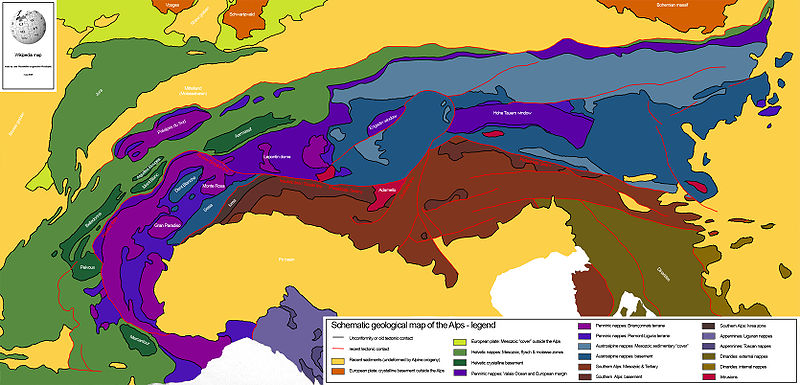
In many spots in the central zone north of the Periadriatic seam large antiforms called anticlinoria can be found, sometimes they are displayed in the outcrops as windows.
In the central part of Switzerland, uplift took place along a ductile north–south normal faultzone called the Rhône-Simplon line.
The rocks of the Helvetic and Austroalpine nappes and the southern Alps did not experience high grade metamorphism in the major Alpine phases in the Cenozoic.
Folding and thrusting is the expression of crustal shortening which is caused by the convergent movements of the European and Adriatic plates.
In the Permian, the main deposits in Europe were sandstone and conglomerate, products of erosion in the Hercynic mountain range.
At the same time, crustal extension took place because the mountain range was isostatically unstable (this is called orogenic collapse).
Due to extension, basins formed along the axis of the mountain range and felsic volcanism occurred.
Eventually, a new ocean will cut through east Africa as the rift develops, dividing a large section of land from the main continent.
Caught in the middle of the merging continents, the area of the Tethys Sea between Africa and Eurasia began to shrink as oceanic crust subducted beneath the Adriatic plate.
The tremendous forces at work in the lower continental foundation caused the European base to bend downward into the hot mantle and soften.
The slow folding and pleating of the sediments as they rose up from the depths is believed to have initially formed a series of long east–west volcanic island arcs.
In the late Cretaceous the first continental collision took place as the northern part of the Adriatic subplate collided with Europe.
The part of the Adriatic plate that was deformed in this phase is the material that would later form the Austroalpine nappes and the Southern Alps.
On the southern margins of the European continent shallow seas formed limestone deposits, that would later be (in the Alps) incorporated into the Helvetic nappes.
[3] After subduction of oceanic crust of the European plate collision nearly completely stopped in the Western and Central Alps (See map Figure 2).,[3][4] These parts are still uplifted up to 2.5 mm/year in some areas.
The tremendous glaciers that flowed out of the mountain valleys repeatedly covered all of the Swiss plain and shoved the topsoil into the low rolling hills seen today.
As the last ice age ended, it is believed that the climate changed so rapidly that the glaciers retreated back into the mountains in only some 200 to 300 years time.
In the last 150 years humans have changed the flow and levels of all the rivers and most of the extensive wetlands and small lakes have disappeared under the effects of farming and other development.
It has been proposed that the height of mountains in the Dauphiné Alps is limited by glacier erosion, an effect referred to as the glacial buzzsaw.