Earth's magnetic field
However, at irregular intervals averaging several hundred thousand years, Earth's field reverses and the North and South Magnetic Poles abruptly switch places.
A 2021 paleomagnetic study from the University of Liverpool contributed to a growing body of evidence that the Earth's magnetic field cycles with intensity every 200 million years.
[19] This may seem surprising, but the north pole of a magnet is so defined because, if allowed to rotate freely, it points roughly northward (in the geographic sense).
Over the last 180 years, the North Magnetic Pole has been migrating northwestward, from Cape Adelaide in the Boothia Peninsula in 1831 to 600 kilometres (370 mi) from Resolute Bay in 2001.
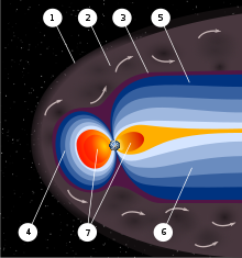
[28] There are also two concentric tire-shaped regions, called the Van Allen radiation belts, with high-energy ions (energies from 0.1 to 10 MeV).
Periods of particularly intense activity, called geomagnetic storms, can occur when a coronal mass ejection erupts above the Sun and sends a shock wave through the Solar System.
[13] Frequently, the Earth's magnetosphere is hit by solar flares causing geomagnetic storms, provoking displays of aurorae.
[38] A 1995 study of lava flows on Steens Mountain, Oregon appeared to suggest the magnetic field once shifted at a rate of up to 6° per day at some time in Earth's history, a surprising result.
[39] However, in 2014 one of the original authors published a new study which found the results were actually due to the continuous thermal demagnitization of the lava, not to a shift in the magnetic field.
Evidence for these geomagnetic reversals can be found in basalts, sediment cores taken from the ocean floors, and seafloor magnetic anomalies.
In lava flows, the direction of the field is "frozen" in small minerals as they cool, giving rise to a thermoremanent magnetization.
[8] Radiometric dating of lava flows has been used to establish a geomagnetic polarity time scale, part of which is shown in the image.
This forms the basis of magnetostratigraphy, a geophysical correlation technique that can be used to date both sedimentary and volcanic sequences as well as the seafloor magnetic anomalies.
[8] Paleomagnetic studies of Paleoarchean lava in Australia and conglomerate in South Africa have concluded that the magnetic field has been present since at least about 3,450 million years ago.
The Earth and most of the planets in the Solar System, as well as the Sun and other stars, all generate magnetic fields through the motion of electrically conducting fluids.
[56] The heat is generated by potential energy released by heavier materials sinking toward the core (planetary differentiation, the iron catastrophe) as well as decay of radioactive elements in the interior.
A Coriolis effect, caused by the overall planetary rotation, tends to organize the flow into rolls aligned along the north–south polar axis.
[62] Simulating the geodynamo by computer requires numerically solving a set of nonlinear partial differential equations for the magnetohydrodynamics (MHD) of the Earth's interior.
For decades, theorists were confined to creating kinematic dynamo computer models in which the fluid motion is chosen in advance and the effect on the magnetic field calculated.
[63] The first self-consistent dynamo models, ones that determine both the fluid motions and the magnetic field, were developed by two groups in 1995, one in Japan[64] and one in the United States.
Because the salty water is only slightly conductive, the interaction is relatively weak: the strongest component is from the regular lunar tide that happens about twice per day (M2).
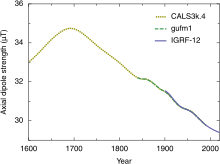
The later Ørsted satellite allowed a comparison indicating a dynamic geodynamo in action that appears to be giving rise to an alternate pole under the Atlantic Ocean west of South Africa.
The military determines local geomagnetic field characteristics, in order to detect anomalies in the natural background that might be caused by a significant metallic object such as a submerged submarine.
Magnetometers detect minute deviations in the Earth's magnetic field caused by iron artifacts, kilns, some types of stone structures, and even ditches and middens in archaeological geophysics.
Basalt — the iron-rich, volcanic rock making up the ocean floor[74] — contains a strongly magnetic mineral (magnetite) and can locally distort compass readings.
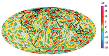
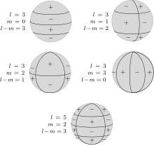
The most common way of analyzing the global variations in the Earth's magnetic field is to fit the measurements to a set of spherical harmonics.
Analyses of the Earth's magnetic field use a modified version of the usual spherical harmonics that differ by a multiplicative factor.
[13] Spherical harmonic analysis can be used to distinguish internal from external sources if measurements are available at more than one height (for example, ground observatories and satellites).
[85] Some researchers have found that cows and wild deer tend to align their bodies north–south while relaxing, but not when the animals are under high-voltage power lines, suggesting that magnetism is responsible.
Neither power lines nor cellphone signals are to blame for the electromagnetic field effect on the birds;[89] instead, the culprits have frequencies between 2 kHz and 5 MHz.


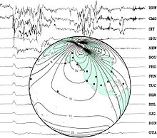
Globe : map showing locations of observatories and contour lines giving horizontal magnetic intensity in μ T .