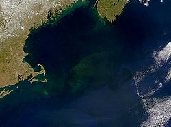
Georges Bank
Lying adjacent to New England's famous seaports, Georges Bank is singlehandedly responsible for the development of coastal fisheries in towns such as Gloucester, Massachusetts, and Yarmouth, Nova Scotia.
Bottom trawlers, however, damaged the sea floor coral and sponge habitats, and federal fisheries regulations aim to control this large scale overfishing to establish future sustainability.
[3] None were successful, however, and both Canada and the United States have since imposed moratoriums on oil exploration and production on the Georges Bank, to ensure fisheries conservation.
[4] The decision by Canada and the United States to extend fisheries jurisdiction out to 200 miles in 1977 led to overlapping claims on Georges Bank, and resulted in quickly deteriorating relations between fishers from both countries.
Despite the protection, commercial fishing for deep sea red crab and American lobster was allowed to continue within the monument for a grace period of seven years.