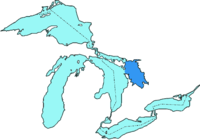
Georgian Bay
Georgian Bay is surrounded by (listed clockwise) the districts of Manitoulin, Sudbury, Parry Sound and Muskoka, as well as the more populous counties of Simcoe, Grey and Bruce.
The Main Channel separates the Bruce Peninsula from Manitoulin Island and connects Georgian Bay to the rest of Lake Huron.
The North Channel, located between Manitoulin Island and the Sudbury District, west of Killarney, was once a popular route for steamships and is now used by a variety of pleasure craft to travel to and from Georgian Bay.
The shores and waterways of the Georgian Bay are the traditional domain of the Anishinaabeg First Nations peoples to the north and Huron-Petun (Wyandot) to the south.
Samuel de Champlain, the first European to explore and map the area in 1615–1616, called it "La Mer douce" (the sweet/calm/fresh sea), which was a reference to the bay's freshwater.
[2] In 1822, after Great Britain had taken over the territory, Lieutenant Henry Wolsey Bayfield of a Royal Navy expedition named it as "Georgian Bay" (after King George IV).
[4][5] Eastern Georgian Bay is part of the southern edge of the Canadian Shield, granite bedrock exposed by the glaciers at the end of the last ice age, about 11,000 years ago.
The western part of the bay, from Collingwood north, and including Manitoulin, Drummond, Cockburn and St. Joseph islands, borders the Niagara Escarpment.
In October 2004, the Georgian Bay Littoral was declared a Biosphere Reserve by UNESCO.Archaeological records reveal an Aboriginal presence in the southern regions of the Canadian Shield dating from 11,000 years ago.
[8]: 57 At the time of European contact, the Ojibwe and Ottawa First Nations, both of whom call themselves Anishinaabe (plural: Anishinaabeg), lived along the northern, eastern and western shores of Georgian Bay.
Names of islands such as "Manitoulin" (from Gitchi Manitou, the Great Spirit who left the bay as a source of life for the first people) and "Giant's Tomb" are indicative of the richness of the cultural history of the area.
The first European to visit this area was likely Étienne Brûlé, who at age less than 20, in 1610 was sent to live as an interpreter trainee with the Onontchataronon, an Algonquian people of the Ottawa River.
They travelled every winter to live with the Arendarhonon people of the Huron-Wendat Nation at the southern end of Georgian Bay, in the area now called Huronia.
At the same time another young interpreter trainee, a youth remembered only as Thomas, who was employed by the French surgeon and trader Daniel Boyer, also likely made it to Huronia, in the company of the Onontchataronon, another member of the confederacy.
In 1615, Brulé's employer, the French explorer Samuel de Champlain, made his own visit to Georgian Bay and overwintered in Huronia.
On August 17, at the mouth of the Nottawasaga River near Wasaga Beach, the British schooner HMS Nancy was sunk by three American vessels.
Several weeks later, Nancy was avenged when British boarding parties in the De Tour Passage surprised and captured two of the three American vessels.
The passenger ferry MS Chi-Cheemaun travels from Tobermory across the Main Channel to South Baymouth on Manitoulin Island.