Gildersleeve Mountain
Gildersleeve Mountain is located in the Chapin Forest Reservation of Lake Metroparks and is referred to as the "scenic overlook".
It is visible when the view is unobstructed by buildings or trees from downtown Cleveland, Mayfield Heights, and from the shore and waters of Lake Erie.
The views to the north and east were once very good with most of the landscape of Kirtland and the lakeshore of Lake County visible.
An active natural gas well was drilled in 2006, and the forested areas are logged for hardwood maple and oak.
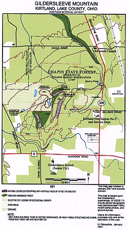
As the map to the right shows, the topography of Gildersleeve Mountain had been changed significantly by human activity.
The sand and gravel quarry on the west side was active for more than 100 years before shutting down in 1968 and being acquired by the state of Ohio.
The road and some trails have been used for the same period of time, but others were put in by the state of Ohio after it acquired the property in 1949, and still others have been added or re-routed by Lake Metroparks.
In 2007 the former quarry access area and orchard on the west side will be developed into home sites.
There was a chimney associated with this foundation until it was blown down during the Ohio Fireworks Derecho that struck the Cleveland region on July 4, 1969.
The water caught by this cistern is filtered through the Sharon conglomerate and seeps out of the base of the outcropping.
There are numerous seeps all around Gildersleeve Mountain, and they are the source of the creeks that run off into the Chagrin River watershed.
They create ravine systems that cut through layers of rock and provide interesting places to study local geology.
The Quarry Creek ravine accessible from the Old South Church property cuts down to the Cleveland Shale layer before crossing Eagle road.
Around 380 to 300 million years ago the area was on the Earth's equator as a part of the Pangaea super continent.
Again Cleveland shale is not visible on Gildersleeve Mountain but can easily be found in the nearby Chagrin River valley between 800 and 900 feet (270 m) msl.
Faster-running water carried larger pebbles along with the sand, and this was deposited very near shore, or in river or stream deltas and estuaries.
It is Sharon conglomerate outcroppings that up make most of the spectacular ledges that are found on the southeast, north, and western sides of Gildersleeve Mountain.
The ledges have been split and eroded to create up to three distinct sets of formations separated by deeper crevasses.
As mentioned earlier, glaciation has played an important part in the geology of Gildersleeve Mountain.
Glaciers are the major erosive force in the region and ground down the higher elevations while scooping out the [Great Lakes].
In second growth areas mixed mesophytic forest is predominant and generally these trees are about 100 to 150 years old.
The hemlock hardwood forest is one of the most unusual and interesting, but not uncommon on the Allegheny Plateau in the region.
Interesting fungi are present, but these disappear quickly given the fact that Gildersleeve Mountain is within a major American metropolitan area.
Dragonflies and damselflies (odonata) are of special interest to naturalists of the region and Gildersleeve mountain has been a site of recent discoveries.
One of Kirtland's first settlers, Christopher Crary, recalled rattlesnakes in the 1820s or 30s in his memoir: "On Gildersleeve mountain twenty three were killed in one day, and they soon became extinct.
Barred owls are common year round residents and can be found by listening and watching carefully.
Eastern bluebird is common in the more open areas, wood thrush is found nesting wherever trees create a canopy overhead.
Scarlet tanager, rose-breasted grosbeak, American goldfinch, house finch, and song sparrow are also common nesters.
Dark-eyed junco, is a prolific nester and abundant year round on Gildersleeve mountain, not just in the winter, as in most of the Cleveland region.
Uncommon winter visitors have included pine siskins, common redpoll, and evening grosbeak.