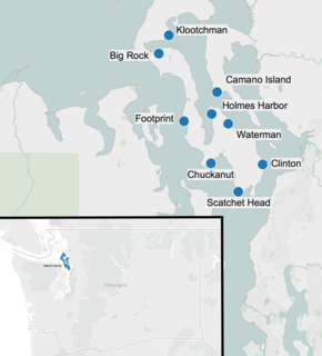
Glacial erratic boulders of Island County, Washington
Download coordinates as: Glacial erratic boulders in Island County are a remnant of the Pleistocene glaciation that created Puget Sound and transformed the surfaces of what are now Island County's main landmasses: Whidbey Island and Camano Island.
South of Deception Pass, the two islands' surfaces and beaches are completely composed of glacial till.
[1][2]: 5 Abundant glacial erratic boulders lie on the islands, their beaches, and under the near-shore waters.
[3][4] 48°12′38″N 122°41′14″W / 48.21056°N 122.68722°W / 48.21056; -122.68722 (Big Rock (Coupeville)) 48°07′43″N 122°29′59″W / 48.12861°N 122.49972°W / 48.12861; -122.49972 (Camano Island State Park erratic) 47°58′30″N 122°31′07″W / 47.97500°N 122.51861°W / 47.97500; -122.51861 (Chuckanut erratic) 47°58′23.7″N 122°21′9.36″W / 47.973250°N 122.3526000°W / 47.973250; -122.3526000 (Clinton erratic) 48°3′57.96″N 122°36′19.8″W / 48.0661000°N 122.605500°W / 48.0661000; -122.605500 (Footprint Rock) 48°04′52″N 122°31′01″W / 48.08111°N 122.51694°W / 48.08111; -122.51694 (Holmes Harbor erratic)
47°54′51.48″N 122°25′52.32″W / 47.9143000°N 122.4312000°W / 47.9143000; -122.4312000 (Scatchet Head) 48°03′38″N 122°27′47″W / 48.06056°N 122.46306°W / 48.06056; -122.46306 (Waterman Rock)