Glossop
Originally a centre of wool processing, Glossop rapidly expanded in the late 18th century when it specialised in the production and printing of calico, a coarse cotton.
Architecturally, the area is dominated by buildings constructed with the local sandstone; a number of these, including Glossop Gasworks, are grade II listed.
[2] There is evidence of a Bronze Age burial site on Shire Hill (near Old Glossop) and other possibly prehistoric remains at Torside (on the slopes of Bleaklow).
The medieval economy was based on sheep pasture and the production of wool by farmers who were tenants of the Abbot of Basingwerk and later the Talbot family.
A good transport network between Liverpool and Glossop brought in imported cotton which was spun by a labour force with wool spinning skills.
The climate of Glossopdale provided abundant soft water that was used to power mills and finish the cloth, and also gave the humidity necessary to spin cotton under tension.
The mill owners were local men: the Wagstaffs and Hadfields were freeholders from Whitfield; the Shepleys, Shaws, Lees, Garlicks and Platts had farmed the dale.
The Sheffield, Ashton-under-Lyne and Manchester Railway came to Dinting in 1842, but it was the 13th Duke of Norfolk who built the spur line to Howard Town, so that coal could be brought from the collieries at Dukinfield.
Partington built the cricket pavilion, so Samuel Hill-Wood sponsored the football club that for one season, 1899–1900, played in League Division One.
In the Luddite and Chartist times and the period following Peterloo, Glossop was virtually unaffected, despite its proximity to Hyde, a radical hotbed.
Glossop was not ultimately included in the Greater Manchester area established by the Local Government Act 1972, with the residents voting to remain in Derbyshire in 1973.
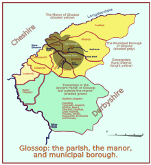
Historically, the ancient parish of Glossop consisted of the ten townships of the manor: Glossop, Hadfield, Padfield, Dinting, Simmondley, Whitfield, Chunal, Charlesworth, Chisworth, Ludworth and nine more: Mellor, Thornsett, Rowarth, Whittle (Whitle), Beard, Ollersett, Hayfield, Little Hayfield, Phoside, Kinder, Bugsworth, Brownside and Chinley.
[20] The remaining parishes of Charlesworth, Chisworth and Ludworth formed Glossopdale Rural District, which remained in existence until 1934 when the parishes were split, Ludworth going into Marple RDC, Chisworth and the greater part of Charlesworth joining Chapel en le Frith RDC and the smaller part—271 acres (1.1 km2)—joining Glossop.
It lies on Glossop Brook, a tributary of the River Etherow, in the area of peat moorland commonly known as the Dark Peak.
The Snake Pass crosses the Pennine Way near Doctor's Gate Culvert (1,680 ft above sea level) before descending to the east to Ladybower Reservoir along the northern side of the River Ashop valley.
The Variscan uplift has caused much faulting and Glossopdale was the product of glacial action in the last glaciation period that exploited the weakened rocks.
The brooks are fed by the peaty soils of the moors thus are acid (pH5.5–7.0); this means the instream wildlife is dependent on food sources from outside the channel.
Glossop's economy was linked closely with a spinning and weaving tradition that had evolved from developments in textile manufacture during the Industrial Revolution.
[26] The present building is a small part of the original complex, which in its heyday employed 1,400 workers operating 123,000 spindles and 2,541 looms.
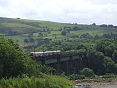
Two men and a woman mistook the parapet of the viaduct for the station platform at Hadfield, alighted from the train and fell 75 feet to their deaths.
[31] It is a popular spot for local amateur photographers and is earmarked for improved access under Glossop's Active Travel Masterplan.
There are generally half-hourly train services, increasing to every 20 minutes during rush hour, along this remaining stub of the former Woodhead Line.
To the west, this road (with the parallel M67 motorway) leads to Manchester, while Sheffield and the Hope Valley lie to the east, via the Snake Pass.
The town also has a number of sports clubs, including tennis, golf, rugby union, cricket, bowls, running, cycling and sailing at Torside reservoir.
The Crown Inn public house at 142 Victoria Street, built in the 1840s, is on the Campaign for Real Ale's National Inventory of Historic Pub Interiors.
[48] Calls for service in the rural areas usually increase during the summer as the population is boosted by approximately twenty million visitors each year to the Peak District and its surrounds.
When Glossop was granted Municipal Borough Status in 1867, the Watch Committee elected to implement its own police force.
[49] Glossop is twinned with Bad Vilbel, a spa town in the Wetteraukreis district of Hesse, Germany, 5 miles (8 km) north-east of Frankfurt.
To encourage visits by individuals and groups to and from the linked towns, particularly by children and young people, and the development of personal contacts, and by doing so to broaden the mutual understanding of the cultural, recreational, educational and commercial activities of the linked towns.Source: The Glossop-Bad Vilbel Twinning AssociationIn 1987 formal twinning ceremonies were held in both towns, with a tree being planted in Norfolk Square.
[50] The two signatories of the charter were Catherine Holtom, the Mayor of High Peak, and Gunther Biwer, Bürgermeister of Bad Vilbel.