Godavari River
[6] It flows east for 1,465 kilometres (910 mi), draining the states of Maharashtra (48.6%), Telangana (18.8%), Andhra Pradesh (4.5%), Chhattisgarh (10.9%) and Odisha (5.7%).
[9] The mohit bandi has been revered in Hindu scriptures for many millennia and continues to harbour and nourish a rich cultural heritage.
In the past few decades, the river has been barricaded by several barrages and dams, keeping a head of water (depth) which lowers evaporation.
Its broad river delta houses 729 persons/km2 – nearly twice the Indian average population density and has a substantial risk of flooding, which in lower parts would be exacerbated if the global sea level were to rise.
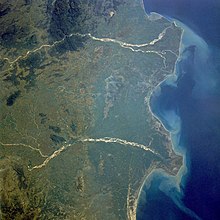
It flows for 1,465 km (910 mi), first eastwards across the Deccan Plateau then turns southeast, entering the Eluru district and Alluri Sitharama Raju district of Andhra Pradesh, until it splits into two distributaries that widen into a large river delta at Dhavaleshwaram Barrage in Rajamahendravaram and then flows into the Bay of Bengal.
[18] Within Nashik district, the river assumes a north-easterly course until it flows into the Gangapur Reservoir created by a dam of the same name.
[citation needed] About 0.5 km (0.31 mi) south of Nashik, the river bends sharply to the east, washing the base of a high cliff formerly the site of a Mughal fort, but which is now being eroded away by the action of floods.
Within Ahmednagar District the river quickly completes its short course, flowing alongside the town of Kopargaon and reaching Puntamba.
[citation needed] Its course is relatively non-significant except for receiving two smaller streams – Indrayani and Masuli – merging at its left and right banks, respectively.
It then runs into the controversial Babli project soon ends its course within Maharashtra, albeit temporarily, at its merger with a major tributary – Manjira.
At the state border, it runs between Sironcha and Somnoor Sangam receiving one tributary at each of those nodal points – the Pranhita and subsequently the Indravati.
[23] The Gautami which is the largest branch of the whole passes along Yanam enclave of Union territory of Puducherry and empties itself into sea at Point Godavery.
[25] Mean annual, minimum and maximum discharge (Q – m3/s) at Rajahmundry (period from 1998/01/01 to 2023/12/31):[2][3] The major left bank tributaries[26] include the Purna, Pranhita, Indravati, and Sabari River, covering nearly 59.7% of the total catchment area of the basin.
[27] Though the river proper flows only for 113 km (70 mi), by virtue of its extensive tributaries Wardha, Wainganga, Penganga, the sub-basin drains all of Vidharba region as well as the southern slopes of the Satpura Ranges.
Before merging into the Bay of Bengal, the Godavari has seven mouths in total and is considered sacred by local Hindus.
[29] However, the original branches of Kauśika, Bhardwaja and Jamadagni does not exist any longer and the pilgrims bathe in the sea at the spots where they are supposed to have been.
Seeing what happened before their eyes, the sages and their wives cried out, "We thought that Gautama-maharishi is a righteous man, but he committed bovicide (killing of a cow or cattle)!".
Therefore, he went to Nashik and observed tapas (penance) to propitiate Tryambakeshvara (a manifestation of the god Shiva), on the advice of the sages, praying for atonement and asking him to make the Ganges flow over the cow.
Shiva was pleased with the sage and diverted the Ganges, which washed away the cow and gave rise to the Godavari River in Nashik.
In olden days a pilgrimage named as sapta sāgara yātra was made by those desirous of offspring along the banks of the holy waters from the seven mouths.
[35] It starts with holy bathing at Tulyabhaga river at Chollangi village on Amavasya during Krishna Paksha of Pushya month as per Hindu calendar.
[citation needed] It is located on the Sileru River which forms boundary between Andhra Pradesh and Odisha states.
Details: The main Godavari River up to the confluence with Pranhita tributary is dammed fully to utilize the available water for irrigation.
The yearly water unutilized is given below There is least possibility to construct new reservoirs in the river basin area due to land submergence and displacement of population.
However, a freshwater coastal reservoir, located on the adjacent sea, with adequate storage capacity (nearly 29 billion m3) is economically feasible to harness the remaining unutilized water in the river.
This is followed by the Precambrian granites and gneisses of the eastern Dharwar Craton, sandstones, shales and limestones of the Gondwana Supergroup, various sedimentary units of Cuddapah and Vindhyan basins, charnockites and khondalites of the Proterozoic Eastern Ghats Mobile Belt and the sandstones of the Rajahmundry Formation.
ka BP reflected a shift of organic carbon and sediment source and a severe decline in vegetation coverage.
[52] The Godavari River basin is endowed with rich mineral deposits such as oil and gas, coal, iron, limestone, manganese, copper, bauxite, granite, laterite, and others.
The following are the few noted deposits: The frequent drying up of the Godavari River in the drier months has been a matter of great concern.
[58] Deemed as being pointless and politically driven,[59] the project raises questions about environmental clearance, displacement of upstream human habitations,[60] loss of forest cover, technicalities in the dam design which are said to play down flood threats and unsafe embankments.