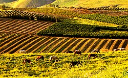
Golan Heights
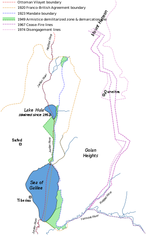
It is bordered by the Yarmouk River in the south, the Sea of Galilee and Hula Valley in the west, the Anti-Lebanon mountains with Mount Hermon in the north and Wadi Raqqad in the east.
[5] Two thirds of the area was occupied by Israel following the 1967 Six-Day War and then effectively annexed in 1981 – an action unrecognized by the international community, which continues to consider it Israeli-occupied Syrian territory.
[21] After the fall of the Assad regime in December 2024, Israel occupied the rest of the Golan Heights as a "temporary defensive position",[22] followed by two additional Syrian villages, Jamlah and Maaraba.
[43] When Herod the Great ascended to power in Judaea during the latter half of the first century BC, the region as far as Trachonitis, Batanea and Auranitis was put under his control by Augustus Caesar.
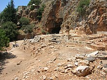
These synagogues, built from the abundant basalt stones of the region, were influenced by those in the Galilee but exhibited their own distinctive characteristics; prominent examples include Umm el-Qanatir, Qatzrin and Deir Aziz.
[citation needed] Data from surveys and excavations combined show that the bulk of sites in the Golan were abandoned between the late 6th and early 7th century as a result of military incursions, the breakdown of law and order, and the economy brought on by the weakening of the Byzantine rule.
When the power of the governing regime declined, as happened during the early Muslim period, nomadic trends increased and many of the rural agricultural villages were abandoned due to harassment from the Bedouins.
During the 1560s, Ottoman official Mustafa Lala Pasha established al-Qunaytira as an important regional center, building a caravanserai, a mosque and shops, and endowing them with properties in dozens of villages around the Golan.
[83] In 1885, civil engineer and architect, Gottlieb Schumacher, conducted a survey of the entire Golan Heights on behalf of the German Society for the Exploration of the Holy Land, publishing his findings in a map and book entitled The Jaulân.
[89] A village called Tiferet Binyamin was established on lands purchased from Saham al-Jawlan by the Shavei Zion Association based in New York,[88] but the project was abandoned after a year when the Turks issued an edict in 1896 evicting the 17 non-Turkish families.
[93] Between 1904 and 1908, a group of Crimean Jews settled near the Arab village of al-Butayha in the Bethsaida Valley, initially as tenants of a Kurdish proprietor with the prospects of purchasing the land, but the arrangement faltered.
[95] In 1921–1930, during the French Mandate, the Palestine Jewish Colonization Association (PICA) obtained the deeds to the Rothschild estate and continued to manage it, collecting rents from the Arab peasants living there.
[98] The commission submitted its final report on 3 February 1922, and it was approved with some caveats by the British and French governments on 7 March 1923, several months before Britain and France assumed their Mandatory responsibilities on 29 September 1923.
[120][121] Jan Mühren, a former UN observer in the area at the time, told a Dutch current affairs programme that Israel "provoked most border incidents as part of its strategy to annex more land".
[138] The Golan Heights Law was declared "null and void and without international legal effect" by United Nations Security Council Resolution 497, which also demanded that Israel rescind its decision.
[153] Dennis Ross, U.S. President Bill Clinton's chief Middle East negotiator, blamed "cold feet" on the part of Israeli Prime Minister Ehud Barak for the breakdown.
[155] In June 2007, it was reported that Prime Minister Ehud Olmert had sent a secret message to Syrian President Bashar al-Assad saying that Israel would concede the land in exchange for a comprehensive peace agreement and the severing of Syria's ties with Iran and militant groups in the region.
[157] In April 2008, Syrian media reported Turkey's Prime Minister Recep Tayyip Erdoğan had told President Bashar al-Assad that Israel would withdraw from the Golan Heights in return for peace.
[168] In June 2009, Israeli President Shimon Peres said that Assad would have to negotiate without preconditions, and that Syria would not win territorial concessions from Israel on a "silver platter" while it maintained ties with Iran and Hezbollah.
[172] The White House dismissed Netanyahu's suggestion, stating that President Obama continued to support UN resolutions 242 and 497, and any alterations of this policy could strain American alliances with Western-backed Syrian rebel groups.
[183] UNDOF had: "repeatedly engaged with the IDF to protest the construction"[183] In December, Israeli forces occupied Mount Hermon advancing as far as the town of Beqaasem, situated about 25 kilometers from Damascus.
Holding Mount Hermon - at 2,800 meters the highest point in Syria - would facilitate Israeli electronic surveillance deep in Syrian territory and provide additional warning with respect to military developments in the region.
[182] Claims on the territory include the fact that an area in northwestern of the Golan region, delineated by a rough triangle formed by the towns of Banias, Quneitra and the northern tip of the Sea of Galilee, was temporarily part of the British Palestine Mandate in which the establishment of a Jewish national home had been promised.
[188][better source needed] Accordingly, it was demarcated so that all of the Sea of Galilee, including a 10-metre (33 ft) wide strip of beach along its northeastern shore, would stay inside Mandatory Palestine.
From the Sea of Galilee north to Lake Hula the boundary was drawn between 50 and 400 metres (160 and 1,310 ft) east of the upper Jordan River, keeping that stream entirely within Mandatory Palestine.
[201] A series of publications appeared, partly assisted by Hezbollah and Amal, and a committee which formed in the Lebanese town of Shebaa wrote to the UN in 1986 protesting Israeli occupation of their lands.
[225] Under the subsequent administration of President Joe Biden, the U.S. State Department's annual report on human rights violations around the world once more refers to the West Bank, Gaza Strip, East Jerusalem and the Golan Heights as being territories occupied by Israel.
[233] Between 80,000[125] and 130,000[126] Syrians fled or were driven from the Heights during the Six-Day War and around 7,000 remained in the Israeli-held territory in six villages: Majdal Shams, Mas'ade, Buq'ata, Ein Qiniyye, Ghajar and Shayta.
The Economist likewise reported that "Some optimists see the future Golan as a sort of Hong Kong, continuing to enjoy the perks of Israel's dynamic economy and open society, while coming back under the sovereignty of a stricter, less developed Syria."
[263] On 23 April 2019, Israel Prime Minister Benjamin Netanyahu announced that he would bring a resolution for government approval to name a new community in the Golan Heights after U.S. President Donald Trump.