Gordion
It was located at the site of modern Yassıhüyük, about 70–80 km (43–50 mi) southwest of Ankara (capital of Turkey), in the immediate vicinity of Polatlı district.
This event, and the subsequent deposition of up to five meters of clay above the burnt level, sealed and preserved many buildings and hundreds of objects from the Early Phrygian phase, providing an astonishing insight into the character of the elite district of an Iron Age citadel, unique in Anatolian archaeology.
As such, the Early Phrygian Destruction Level provides well-dated comparative material for other sites in the region and constitutes a key fixed point in Central Anatolian chronology.
[11] Archaeologists at first interpreted the Destruction Level as the remains of a Cimmerian attack, c. 700 BCE, an event referred to much later by Strabo and Eusebius as resulting in the death of King Midas.
Beginning in 2000, a renewed program of radiocarbon dating, dendrochronological analysis, and a closer examination of the objects in the Destruction Level began.
A date of c. 800 BCE for the Early Phrygian Destruction Level has been widely accepted by scholars working throughout Central Anatolia,[16][17][18][19][20] with objections voiced only by Muscarella and Keenan.
The fortifications at Gordion at this time expanded to include a pair of forts to the north and south of the Citadel Mound connected by a circuit wall that enclosed an area over twenty-five hectares, the Lower Town.
During the Middle Phrygian period, Gordion grew to its largest size, encompassing an area of settlement of approximately one hundred hectares.
In the course of the 6th century BCE, the kingdom of Lydia, Phrygia's neighbor to the southwest, began to exert influence within Anatolia, likely at the expense of Phrygian control.
The incursion of Cyrus the Great and the Achaemenid Empire into Anatolia, beginning in 546 BCE, spelled the end of any Lydian control and of Phrygian autonomy at Gordion.
According to the Greek historian Herodotus, King Midas was the first foreigner to make an offering at the sanctuary of Delphi's Temple of Apollo, dedicating the throne from which he gave judgment.
[23] During his reign, according to Strabo, the nomadic Cimmerians invaded Asia Minor, and in 710/709 BCE, Midas was forced to ask for help from the Assyrian king Sargon II.
Tumulus MM was excavated in 1957 by Young's team, revealing the remains of the royal occupant, resting on purple and golden textiles in an open log coffin, surrounded by a vast array of magnificent objects.
The Tumulus MM funeral ceremony has been reconstructed, and scientists have determined that the guests at the banquet ate lamb or goat stew and drank a mixed fermented beverage.
Despite its relegation in status, Gordion initially continued to prosper under the Achaemenids, with tumulus burials and monumental buildings maintained through the 6th century.
The settlement at Gordion during the Hellenistic period shows a distinctly residential character, with large houses built over the public buildings on the Citadel Mound and no evidence of habitation in the Lower or Outer Towns.
In 189 BCE, the Roman consul Gnaeus Manlius Vulso campaigned through Galatia, forcing the inhabitants of Gordion to temporarily abandon the site.
[33] Recent excavations have revealed lime-coated pits and ovens on the western side of the Citadel Mound, signalling food preparation and storage.
The village of Bebi, located to the west of the Citadel Mound, was the main site of habitation in the area during the 19th and 20th centuries but was destroyed during the course of the battle.
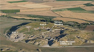
[40] Since 2009, the project has undertaken a renewed program of architectural conservation on the Terrace Building Complex on the Citadel Mound, the large industrial quarter that burned in the Destruction Level c. 800 BCE.
[41] From 2014 to 2019, the architectural conservation team focused its efforts on restoring the South Bastion of the East Citadel Gate, affected by an earthquake in 1999.
[42] The use of magnetometry, electrical resistivity tomography, and ground-penetrating radar have allowed for a more complete reconstruction of the defense network and urban districts of the city during the Iron Age, providing evidence for a ditch and wall system surrounding the Outer Town to the west and confirming the existence of a second fort protecting the Lower Town at Kuş Tepe to the north.
The results of the excavations at Gordion are the subject of study for an international team of scholars, with ongoing research into all periods of the site's history.