Gorontalo
The province covers a total land area of 12,025.15 square kilometres (4,642.94 sq mi) and had a population of 1,040,164 at the 2010 Census,[5] and 1,171,681 at the 2020 Census;[6] the official estimate as at mid 2023 was 1,213,180 (comprising 611,780 males and 601,400 females), resulting in a population density of 100.887 inhabitants per square kilometre (261.30/sq mi).
[1] The province is known by the nicknames "Porch of Medina" (Indonesian: Bumi Serambi Madinah), an allusion to the cradle of Islamic civilisation used because the pre-colonial kingdoms of Gorontalo applied Islamic law as a basis for implementing the law, in the fields of government, society and the courts,[7] and "Karawo Province" for the local karawo [id] embroidery.
Historically, Gorontalo has been the centre for the spread of Islam in Eastern Indonesia, dating back to the pre-colonial era.
Gorontalo was briefly occupied by the Japanese during World War II, before finally becoming part of the independent Republic of Indonesia.
Previously Gorontalo City became one of the centers of Islamic religion in Eastern Indonesia, in addition to Ternate (now part of North Maluku Province).
This is because of its strategic location, its position facing directly into the Gulf of Tomini (south) and the Sulawesi Sea (north).
The first Westerners to come to Indonesia were the Portuguese, who sailed from Malacca to Gresik in East Java and then to the Moluccas, where spices were collected.
Gorontalo was important to the VOC because it contained food ingredients such as rice, chocolate and coconut, besides that in the mountains there are also gold mines, such as in the areas of Samalata, Marisa, Bonepantai, and Bintauna.
Subsequent developments, the political transition of the VOC to the Dutch East Indies at the turn of the 18th century to the 19th century was marked by VOC bankruptcy caused by various factors, such as accounting fraud, corruption, weak employee capabilities, monopoly systems, and systems forced which brought about the moral deterioration of the rulers and the suffering of the population.
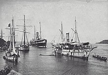
The Japanese occupied Gorontalo during World War II, ending three centuries of Dutch colonial rule.
Gorontalo was subjected to air bombing as well as naval shelling by the Allies over the course of the war, resulting in severe civilian casualties.
In 1957, chaos and lack of attention by the central government in Jakarta resulted in a rebellion by Permesta which was based in Manado, the capital of North Sulawesi.
Counting the Exclusive Economic Zone to the north where Philippines is at the border, the total sea area of the province is more than 50,500 km2 (19,500 sq mi).
As the peninsula of which Gorontalo Province is a part is located near the equator, this area has a fairly high air temperature.
In 2023, Gorontalo Province consisted of 77 districts (kecamatan) comprising 734 villages (rural desa and urban kelurahan).
As of 2024, the list of regencies and cities in Gorontalo province is given in the table below with their areas and their populations at the 2010[5] and 2020[6] censuses, together with the official estimates as at mid 2023.
[1] The province now forms one of Indonesia's 84 national electoral districts to elect members to the People's Representative Council.
Gorontalo has a strategic geographic location for the national economy, because it has trade routes that are directly dealing with neighboring countries such as the Philippines, Malaysia, Brunei, Hong Kong, Taiwan, Japan and South Korea.
In addition, Gorontalo is also one of the areas that is the entrance of trade routes from the Americas to countries in the Asia-Pacific region, such as Brunei, Singapore and Malaysia.
The Indonesian Government considers that Gorontalo is one of the backbone of the economic, educational and cultural driving force in the Eastern Region of Indonesia.
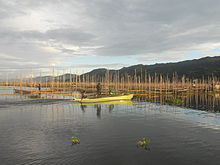
The sea area in Gorontalo, especially in the Gulf of Tomini, holds a lot of natural potential because it is one of the bays that is passed by the equator.
Unfortunately, the utilization rate of new capture fisheries is only 24.05% or 19,771 tons per year.The population in Gorontalo Province in 2020 was 1,171,681 people consisting of 591,349 men and 580,332 women.
They mostly migrated due to the transmigration program enacted during the colonial era until it was abolished in 2015 by the Indonesian government.
In the present time, many non-governmental Islamic organisations such as Nahdlatul Ulama and Muhammadiyah has branch offices in Gorontalo.
In addition, it has been successfully published and approved by the Ministry of Religion Affairs concerning the publication of the Qur'an which is equipped with Gorontaloan language translation.
In addition, local content education in Gorontalo Language is still being maintained as teaching material in elementary schools.
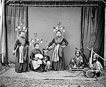
Distinctive characteristics of Gorontalo in the cultural sphere include typical foods, traditional houses, arts, and handicrafts such as filigree or woven basket skullcaps made of rattan called karanji upiya.
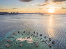
Tourist spots in Gorontalo include the following: Pulo Cinta or "Love Islands" in English is located in Boalemo Regency.
This heart-shaped island is equipped with several very exclusive floating resorts, and certainly shows the exoticism of the charming clear sea.
[34] Olele Marine Park is one of the leading International Underwater Paradise of foreign divers in Bone Bolango Regency.