Goseck Circle
Currently, the site is presented officially by the state archaeologists and the local association that looks after it as a ritual or cult structure.
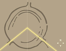
Marketing materials have described the site as one of the oldest "Solar observatories" in the world, but sunrise and sunset during winter and summer solstices are the only evident astronomical alignments emphasized in the remains of the structure.
The circle sits on a piece of land that gradually rises toward the south, not far from where the Unstrut flows into the Saale, at the border of the region known as Leipzig Bay.
[1] The circle was discovered in 1991 by Otto Braasch on an aerial survey photograph that showed circular ridges under a wheat field.
[1] To preserve the endangered remains, the Landesamt für Denkmalpflege und Archäologie Sachsen-Anhalt decided to conduct an excavation.
When archaeologists combined the evidence with GPS observations, they noticed that the two southern openings marked the sunrise and sunset of the winter and summer solstices.
Radiocarbon dating places the construction of the site close to 4900 B.C., while the style of the pottery shards associate it with the stroke-ornamented ware culture of ca.
[1] The southwestern and southeastern entrances face the direction of sunset and sunrise around the date of the winter solstice.
[1] During a ceremony at the first opening of this site to the public, state archaeologist Harald Meller called it "a milestone in archaeological research".
The site is one of a larger group of circular enclosures in the Elbe and Danube region, most of which show similar solstice alignments.