Gotthard Pass
The Gotthard axis is the most important route between Central Switzerland as well as most of the northern part of the country and the southern region of Ticino.
The region of Andermatt lies at the foot of the Furka and Oberalp Passes connecting the Rhone and Rhine Valleys thus making the Gotthard area a strategic place for transports and military (the Swiss Réduit for instance).
The first wooden bridge across Schöllenen Gorge was built around 1220, and in the following years the pass rapidly gained in importance.
The three regions of Uri, Schwyz and Unterwalden (the Waldstätten or "forest communities") gained imperial immediacy under the Hohenstaufen emperors still in the first half of the 13th century.
An important aspect of the early confederacy, expressed in the Pfaffenbrief of 1370, was the guarantee of peace along the road from Zürich to the Gotthard Pass.
The Swiss also had an interest in extending their influence south of the Alps to secure the trade route across the pass to Milan.
Beginning in 1331, they initially exerted their influence through peaceful trade agreements, but in the 15th century, their involvement turned military.
The path across Schöllenen Gorge, and thus across the pass, still carried only foot traffic and pack animals until 1775,[citation needed] when the first carriage made the journey on an improved road.
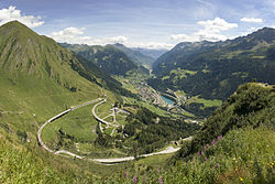
In addition to the National Road 2, crossing the pass and connecting Göschenen with Airolo, several tunnels provide access through the massif.
The first one, the 15 kilometres (9.3 mi) Gotthard Rail Tunnel, opened in 1882 for railway traffic at a cost of around 200 workers' lives (there is uncertainty as to the exact toll).
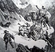
A number of international artists have been inspired by the dramatic scenery of the Gotthard Pass, the Schöllenen Gorge and the Teufelsbrücke.