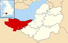
Grade II* listed buildings in West Somerset

Once listed, severe restrictions are imposed on the modifications allowed to a building's structure or its fittings.

In England, the authority for listing under the Planning (Listed Buildings and Conservation Areas) Act 1990 rests with Historic England, a non-departmental public body sponsored by the Department for Digital, Culture, Media and Sport; local authorities have a responsibility to regulate and enforce the planning regulations.

[2] West Somerset is a largely rural area covering 740 square kilometres (290 sq mi).

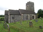
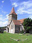
The list includes a large number of churches and chapels, some of which are Norman.

Packhorse bridges over Exmoor streams and some larger ones over rivers in the area are also included.

West Somerset shown within the county of Somerset
2, The Avenue, Minehead
2, The Avenue , Minehead
4, 6 and 8, Church Street, Dunster
4, 6 and 8, Church Street , Dunster
Barn at south entrance to churchyard, Church of St Mary
Causeway Bridge at east entrance to Stogursey Castle
Churchyard Cross About 3 Metres South East Of Porch, Culbone Church
Churchyard Cross, 10m south of porch, Church of Saint Mary
Churchyard Cross, 2 Metres South Of Porch, Church of The Holy Ghost
Churchyard Cross, 8 metres east of chancel, Church of St George
Churchyard Cross, in churchyard about 6 metres south of south aisle, Church of St Andrew
Churchyard Cross, 5m south of porch, Church of St Mary
Cross in Churchyard South of Church Porch
Govett Family Chest Tomb, In Churchyard One Metre West Of Porch, Church of St Mary
Linhay, barn and farm buildings adjoining on north-east side of foldyard at Bratton Court
Remains of Churchyard Cross About 4 Metres East Of South Aisle, Church of All Saints
Remains of Churchyard Cross, About 15 Metres North of North Aisle Door, Church of St Peter
Remains of Churchyard Cross. In Churchyard 2m north-east of Porch, Church of All Saints
Remains of Churchyard Cross. In Churchyard about 18m south of Nave, Church of All Saints
Village Cross, 30m east Of the Carew Arms