Grade I listed buildings in Somerset
In England, the authority for listing under the Planning (Listed Buildings and Conservation Areas) Act 1990[3] rests with English Heritage, a non-departmental public body sponsored by the Department for Digital, Culture, Media and Sport; local authorities have a responsibility to regulate and enforce the planning regulations.
Contract builders carried out the plans, adding a distinctive mix of innovative details and decorations as new designs emerged over the years.
The Sedgemoor district has many buildings related to trade and commerce centred on Bridgwater; while in South Somerset abbeys, priories and farmhouses predominate.
Click here to see an interactive OpenStreetMap with locations of all Grade I listed buildings, Somerset-wide, for which coordinates are included in the list-articles linked below.
Bath and North East Somerset (commonly referred to as BANES or B&NES) is a unitary authority created on 1 April 1996, following the abolition of the County of Avon.
[7] Bath and North East Somerset occupies an area of 220 square miles (570 km2), two-thirds of which is green belt.
[8] The city of Bath is the principal settlement in the district, but BANES also covers Keynsham, Midsomer Norton, Radstock and the Chew Valley.
[13] Bath Abbey was a Norman church built on earlier foundations, although the present building dates from the early 16th century and shows a late Perpendicular style with flying buttresses and crocketed pinnacles decorating a crenellated and pierced parapet.
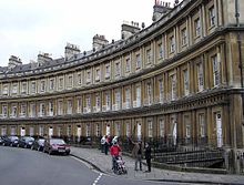
It consists of three long, curved terraces that form a circular space or theatre intended for civic functions and games.
There is also Grade I listed canal architecture outside the city, such as Dundas Aqueduct and Claverton Pumping Station, both designed by John Rennie.
The ruined St Michael's church, itself replacing the one destroyed in an earthquake of 1275,[33] stands on Glastonbury Tor, where the site shows evidence of occupation from Neolithic times and the Dark Ages.
Medieval structures include Farleigh Hungerford Castle, fortified around 1370, and The George Inn at Norton St Philip, used as an army headquarters during the Monmouth Rebellion in 1685, and then as a courtroom to try the rebels in the Bloody Assizes.
The most recent Grade I building in North Somerset is Tyntesfield, a Victorian Gothic Revival estate near Wraxall.
It was acquired by the National Trust in June 2002 after a fund raising campaign to prevent its being sold to private interests and ensure it be opened to the public.
[56] Sedgemoor district is a low-lying area of land close to sea level between the Quantock and Mendip hills, historically largely marsh (or moor).
It contains the bulk of the area also known as the Somerset Levels, including Europe's oldest known engineered roadway, the Sweet Track.
[89] The Hamstone Stoke sub Hamdon Priory is a 14th-century former priest's house of the chantry chapel of St Nicholas,[90] which after 1518 become a farm known as Parsonage Farmhouse.
[97] The house known as The Abbey in Charlton Mackrell takes its name from the site on which it was built, the Chantry Chapel of the Holy Spirit, founded in 1237.
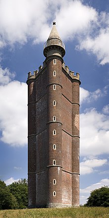
[104] The towers funder, Henry Hoare, planned for it to commemorate the end of the Seven Years' War against France and the accession of King George III.
The Tudor Barrington Court was the first country house acquired by the National Trust, in 1907, on the recommendation of the antiquarian Canon Hardwicke Rawnsley.
[105] Newton Surmaville was built between 1608 and 1612 for Robert Harbin, a Yeovil merchant, on the site of an earlier building, but was extensively altered and enhanced in the 1870s.
[107] The architectural historian Nikolaus Pevsner praised it, saying "Yet all parts blend to perfection with one another and with the gentle sunny landscape that surrounds them.
The district of Taunton Deane covers a population of approximately 100,000[116] in an area of 462 square kilometres (178 sq mi).
[117] It is centred on the town of Taunton, where around 60,000 of the population live[116] and the council are based, and includes surrounding suburbs and villages.
[127][128] In addition to being a listed building the estate is designated Grade I on the English Heritage Register of Parks and Gardens of Special Historic Interest in England.
[137] Dunster has the greatest concentration of Grade I listed buildings, including Dunster Castle, which was built in 1617 on a site which had supported a castle for the previous 600 years;[138] the Yarn Market, which was built in 1609;[139] Gallox Bridge, which dates from the 15th century[140] and the Priory Church of St George which is predominately from the 15th century but includes part of the earlier church on the same site.