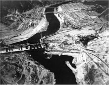
Grand Coulee Dam
The third powerhouse ("Nat"), completed in 1974 to increase energy production, makes Grand Coulee the largest power station in the United States by nameplate capacity at 6,809 MW.
The Grand Coulee is an ancient river bed on the Columbia Plateau created during the Pliocene Epoch (Calabrian) by retreating glaciers and floods.
Originally, geologists believed a glacier that diverted the Columbia River formed the Grand Coulee, but it was revealed in the mid-late 20th century that massive floods from Lake Missoula carved most of the gorge.
Many locals such as Woods, O'Sullivan and Clapp were pumpers, while many influential businessmen in Spokane associated with the Washington Water and Power Company (WWPC) were staunch ditchers.
In 1921, WWPC secured a preliminary permit to build a dam at Kettle Falls, about 110 mi (177 km) upstream from the Grand Coulee.
[14] WWPC planted rumors in the newspapers, stating exploratory drilling at the Grand Coulee site found no granite on which a dam's foundations could rest, only clay and fragmented rock.
[22] President Franklin D. Roosevelt, who took office in March 1933, supported the dam because of its irrigation potential and the power it would provide, but he was uneasy with its $450 million price tag.
In order to secure these areas from further movement and continue excavation, 3-inch (76 mm) diameter pipes were inserted into the mass and chilled with cold liquid from a refrigeration plant.
On December 15, 1936, the Wenatchee Daily World announced the river was diverted and by early the next year, people were arriving in large numbers to see the riverbed.
[35] He spoke to workers and spectators, closing with this statement: "I leave here today with the feeling that this work is well undertaken; that we are going ahead with a useful project, and we are going to see it through for the benefit of our country.
"[36] Soon afterward, Reclamation was allowed to proceed with the high dam plan but faced the problems of transitioning the design and negotiating an altered contract with MWAK.
[37][38] In August 1935, with the help of Roosevelt and a Supreme Court decision allowing the acquisition of public land and Indian Reservations, Congress authorized funding for the upgraded high dam under the 1935 River and Harbors Act.
Within the zone were eleven towns, two railroads, three state highways, about one hundred and fifty miles of country roads, four sawmills, fourteen bridges, four telegraph and telephone systems, and many power lines and cemeteries.
The cut timber was floated downstream and sold to the highest bidder, Lincoln Lumber Company, which paid $2.25 per thousand board feet, equivalent to $49 in 2023.
The Bureau of Reclamation provided housing and located their administrative building at Engineer's Town, which was directly downstream of the construction site on the west side of the river.
[61] After World War II, the growing demand for electricity sparked interest in constructing another power plant supported by the Grand Coulee Dam.
Efforts to build the Third Powerplant were also influenced by competition with the Soviet Union, which had constructed power plants on the Volga River larger than Grand Coulee.
[66] Shortly afterward, Washington Senator Henry M. Jackson, who was influential in constructing the new power plant, announced Reclamation would present the project to Congress for appropriation and funding.
With the possibility of international companies bidding on the project, the Soviets who had just installed a 500 MW hydroelectric generator on the Yenisei River indicated their interest.
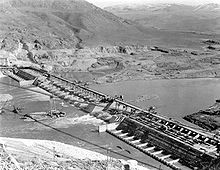
When energy demand is high, the pump-generators can generate electricity with water from the Banks Lake feeder canal adjacent to the dam at a higher elevation.
[87] The dam had severe negative consequences for the local Native American tribes whose traditional way of life revolved around salmon and the original shrub steppe habitat of the area.
[89] Chinook, Steelhead, Sockeye and Coho salmon (as well as other important species, including Lamprey) are now unable to spawn in the reaches of the Upper Columbia Basin.
The lack of fish passage to the upper reaches of the Columbia River wiped out the June hogs, so-called "supersalmon" known to regularly weigh over 80 pounds (36kg).
[91] Grand Coulee Dam flooded over 21,000 acres (85 km2) of prime bottom land where Native Americans had been living and hunting for thousands of years, forcing the relocation of settlements and graveyards.
[92] The Office of Indian Affairs negotiated with the United States Bureau of Reclamation on behalf of tribes who were concerned about the flooding of their grave sites.
The Acquisition of Indian Lands for Grand Coulee Dam, 54 Stat.703 Act of June 20, 1940, allowed the Secretary of the Interior to remove human remains to new Native American grave sites.
[95] In June 1940, the Confederated Tribes of the Colville Reservation hosted a three-day event called the "Ceremony of Tears", marking the end of fishing at Kettle Falls.
The Columbia Basin Project has affected habitat ranges for species such as mule deer, pygmy rabbits and burrowing owls, resulting in decreased populations.
Visitors take a shuttle to view the generators and also travel across the main dam span (otherwise closed to the public) as the formerly used glass elevator is indefinitely out of service.
Gunther von Fritsch was directing a documentary for the Bonneville Power Administration about the construction of the Grand Coulee Dam on the Columbia River and needed a narrator.