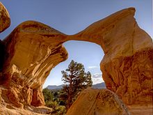
Grand Staircase–Escalante National Monument
The western part of the monument is dominated by the Paunsaugunt Plateau and the Paria River, and is adjacent to Bryce Canyon National Park.
Features include the slot canyons of Bull Valley Gorge, Willis Creek, and Lick Wash which are accessed from Skutumpah Road.
[6][7] The center section is dominated by a single long ridge, called the Kaiparowits Plateau from the west, and Fifty-Mile Mountain when viewed from the east.
On October 3, 2007, the dinosaur's name, Gryposaurus monumentensis (hook-beaked lizard from the monument) was announced in the Zoological Journal of the Linnean Society.
[8][9] Many of the specimens from the Kaiparowits Formation are reposited at the Natural History Museum of Utah in Salt Lake City.
Both groups grew corn, beans, and squash, built brush-roofed pithouses, and took advantage of natural rock shelters.
The first record of white settlers in the region dates from 1866 when Captain James Andrus led a group of cavalry to the headwaters of the Escalante River.
In 1879 the San Juan Expedition crossed through the region on their way to a proposed Mormon colony in the far southeastern corner of Utah.
Traveling on a largely unexplored route, the group eventually arrived at the 1,200-foot (370 m) sandstone cliffs that surrounded Glen Canyon.
After six weeks of labor, including excavation and using explosives to shift rock, they rigged a pulley system to lower their wagons and animals down the resulting road and off the cliff.
[13] It was on September 18, 1996, at the height of the 1996 presidential election campaign by President Bill Clinton, that the national monument was declared and was controversial from the moment of creation.
[17][18] The area's designation as a monument also nixed the Andalex Coal Mine that was proposed for a remote location on the Kaiparowits Plateau.
The SITLa plots within the monument were exchanged for federal lands elsewhere in Utah, plus equivalent mineral rights and $50 million cash by an act of Congress, the Utah Schools and Lands Exchange Act of 1998, supported by Democrats and Republicans, and signed into law as Public Law 105–335 on October 31, 1998.
A process for resolving disputed claims has not been established, and in 1996, the 104th United States Congress passed a law that prohibited the R.S.
[22] On December 4, 2017, President Donald Trump ordered that the monument's size be reduced by nearly 47% to 1,003,863 acres (4,062 km2),[5] with the remainder divided into three areas, two of which border one another along the Paria River.
[27] On his first day in office, President Joe Biden signed an executive order calling for a review of the reduction of the Bears Ears and Grand Staircase–Escalante monuments.