Grand Union Canal
[1] The Birmingham line has a number of short branches to places including Slough, Aylesbury, Wendover, and Northampton.
5. c. xc) was passed authorising a key part of the modernisation scheme of the Grand Union, supported by government grants.
Commercial traffic continued to decline, effectively ceasing in the 1970s, though lime juice was carried from Brentford to Boxmoor until 1981, and aggregates on the River Soar until 1995.
The river and canal part at the base of the Hanwell flight of locks (92–97), after which it traverses Three Bridges, London, Isambard Brunel's final project.
It then heads westward over level ground through Southall, Hayes and Yiewsley until it reaches the gentle valley of the Colne.
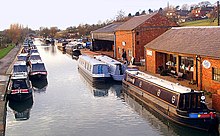
Three miles (5 km) from Norwood on this long level is Bulls Bridge[6] Junction, once the site of the Grand Union Canal Carrying Company's main dockyard.
At Bulls Bridge, the Paddington Arm branches off to the north and runs 12 miles (19 km) to join the Regents Canal at Little Venice (see below).
At suburban Cowley, before the 1930s a rural village, the canal begins to climb the valley of the River Colne north north-west into the adjoining town of Uxbridge.
The original four locks here were replaced in 1819 by five shallower ones to alleviate problems with water supply to the nearby paper mills.
After Kings Langley and Apsley – the site of more former paper mills – the canal passes the town Hemel Hempstead and Boxmoor Common.
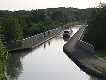
From here the canal follows the course of the River Bulbourne through Bourne End with the well-known swingbridge at Winkwell, and the "Port of Berkhamsted, a small compact town".
At the north-west end of the summit level is Bulbourne Works, where lock gates were manufactured until 2003 for the southern canal network.
Half a mile (800 m) further on, the canal reaches the top of the Marsworth flight of seven locks, which begin the descent to the Vale of Aylesbury.
The Grand Union descends gradually by interspersed locks, past the villages of Cheddington, Horton and Slapton until it reaches Leighton Buzzard.
A few miles further on it enters Milton Keynes at the outskirts of Bletchley at Fenny Stratford Lock, which is unusual in lowering the level by only 12 inches (30 cm).
Once clear of the tunnel, the canal passes Blisworth village and reaches Gayton Junction where the Northampton Arm branches off to the east.
The long level stretch continues past several villages including Nether Heyford and Weedon Bec and is very rural in character.
At Whilton, the canal reaches the bottom of the Buckby flight of seven locks which raise it to Braunston summit the village of which parish is 5 miles (8.0 km) away.
A few miles further on the canal passes through the 2040-yard (1865-m) Braunston Tunnel, which pierces a low range of hills that are part of the Northamptonshire uplands.
The north section leads to Rugby and Coventry; the southward fork carries both the Oxford Canal and the Grand Union for 5 miles (8.0 km) to Napton Junction.
Shortly after Napton Junction, the Grand Union reaches three locks at Calcutt, which begin the descent to the Warwickshire River Avon.
After a 3-mile (5-km) level, the canal descends into the valley of the River Leam by the Stockton flight of 10 locks (often known as 'the Itchington Ten').
Above the eighth lock down the flight, a short arm (now used as pleasure craft moorings) used to serve Southam cement works.
[8] After half a mile the mainline reaches the bottom of the Hatton flight of 21 locks that lift the canal up out of the Avon Valley.
Finally, an 11-mile (18-km) level takes the canal through Elmdon Heath, Solihull, Acocks Green and Tyseley to the heart of Birmingham.
It was originally the main line of the Warwick and Birmingham Canal, 1799, leading to the terminus and a basin with wharfs for timber.
[15] From Milton Keynes, the canal is planned to pass beneath the M1 utilising an existing cattle creep, then cross over Brogborough Hill, and across the Marston Vale through to the River Great Ouse in Kempston.
The predecessor to the Canal and River Trust, British Waterways, received mild financial support indications from the two local authorities covering Slough and Eton, Berkshire to extend the Slough Arm to join the Thames, via any course i.e. covering a minimum 2 miles (3.2 km); the 2008-estimated cost was £30 million.