1960 Valdivia earthquake
The resulting tsunamis affected southern Chile, Hawaii, Japan, the Philippines, eastern New Zealand, southeast Australia, and the Aleutian Islands.
The main tsunami traveled across the Pacific Ocean and devastated Hilo, Hawaii, where waves as high as 10.7 metres (35 ft) were recorded over 10,000 kilometres (6,200 mi) from the epicenter.
Telecommunications to southern Chile were cut off and President Jorge Alessandri cancelled the traditional ceremony of the Battle of Iquique memorial holiday to oversee the emergency assistance efforts.
[16] The earthquake interrupted and effectively ended a protest by coal miners from Lota, who were attempting to march to Concepción to demand higher salaries.
[18] Soil subsidence also destroyed buildings, deepened local rivers and created wetlands in such places as the Río Cruces and Chorocomayo, a new aquatic park north of the city.
[21] With the exception of poor building sites, the zone of Mercalli scales intensities of VII or more all lay west of the Andes in a strip running from Lota (37° S) southwards.
[24] Earthquake-induced tsunamis affected southern Chile, Hawaii, Japan, the Philippines, China,[25] eastern New Zealand, southeast Australia, and the Aleutian Islands.
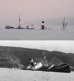
[27] In the Valdivia River and Corral Bay, several vessels were wrecked by the earthquake, among them Argentina, Canelo, Carlos Haverbeck, Melita, and the salvaged remnants of Penco.
[27] The schooner La Milagrosa departed from Queule on 22 May to load a cargo of Fitzroya wood shingles in a small port south of Corral.
[30] Some kilometres north of Mahuín at the coastal town of Queule, a carabinero reported hundreds of people dead or missing some days after the tsunami.
The wave, most likely produced by an earthquake-triggered sediment slide at the lake bottom, killed two people and destroyed a pier in San Carlos de Bariloche city.
To avoid the destruction of the city, several military units and hundreds of workers from ENDESA, CORFO, and MOP started an effort to control the lake.
[36] Twenty-seven bulldozers were put into service, but they had severe difficulties moving in the mud near the dams, so dykes had to be constructed with shovels from June onwards.
By 23 June, the main dam had been lowered from 24 to 15 m (79 to 49 ft), allowing 3 billion cubic metres of water to leave the lake gradually, but still with considerable destructive power.
[38] Between two sparsely populated and isolated Andean valleys, the eruption had few eyewitnesses and received little attention by local media, which was preoccupied with the severe and widespread damage and losses caused by the earthquake.
[39] The eruption was first noticed and reported as an explosion by the crew of a United States Air Force plane that was heading to Santiago from Puerto Montt.
[48][49] Land subsidence in Corral Bay improved navigability as shoal banks, produced earlier by sediments from Madre de Dios and other nearby gold mines, sank and were compacted.
[50] Parts of the botanical garden of the Austral University of Chile that were next to Cau-Cau River and the city's southern outskirts along Route 206 were permanently flooded.
[51][52] The earthquakes damaged an area that had suffered a long period of economic decline, which began with shifts in trade routes due to the expansion of railroads in southern Chile and the opening of the Panama Canal in 1914.
The bulk of the damage in Puerto Montt was located in the neighborhood of Barrio Modelo and the northern part of Bahía Angelmó, where artificial fills subsided.
More specifically, the German and Danish governments helped to create the Centro Tecnológico de la Leche (the Milk Technological Centre) in the Southern University of Chile.
[58] A large area of former pastures and cultivated fields around the lower course of Cruces River was permanently flooded as a result of c. 2 m of subsidence caused by the earthquake.
Egeria densa and other plants created a rich aquatic ecosystem that attracted a permanent bird fauna, notably black-necked swans.
The efforts of President Alessandri led to the creation of a new institutionality in order to facilitate future emergency preparation and to tackle the country's recovery after the earthquake.
CORFO also created the National Company of Telecommunications (ENTEL) out of a pressing need to improve and modernize communication efforts in times of disaster.
[66][68] In the coastal village Collileufu (La Araucanía Region), native Lafkenches carried out a human sacrifice during the days following the main earthquake.
Juana Namuncura Añen, a local machi, demanded the sacrifice of the grandson of Juan Painecur, a neighbor, in order to calm the earth and the ocean.
[69][70] The victim was 5-year-old José Luis Painecur, an "orphan" (huacho) whose mother had gone to work as a domestic worker in Santiago and left her son under the care of his father.
[71] An earthquake of similar magnitude occurred in this area around 1800 BC, as has been determined by dating charcoal and shells washed into the Atacama Desert by the tsunami.
[77] On 27 February 2010 at 03:34 local time, an 8.8 magnitude earthquake occurred just to the north (off the coast of the Maule region of Chile, between Concepción and Santiago).