Great Lakes tectonic zone
Algoman orogeny added landmass to the Superior province by volcanic activity and continental collision along a boundary that stretches from present-day South Dakota, U.S., into the Lake Huron region near Sudbury, Ontario, Canada.
Collision began along the Great Lakes tectonic zone with the Algoman mountain-building event and continued for tens of millions of years.
During the Late Archean Eon the Algoman orogeny – which occurred about 2,750 million years ago – added landmass through volcanic activity and continental collision along a boundary that stretches from present-day South Dakota, U.S., into the Sudbury, Ontario, Canada, region.
[3] The collision of the gneissic Minnesota River Valley (MRV) subprovince onto the southern edge of the Superior province was another process in the slow change in tectonics[4] which marks the end of the Archean Eon.
This gneissic terrane originally extended several hundred kilometers east to west, making it more of a protocontinent than a future Superior province belt.
[4] Tectonism along the zone began during the docking of the two terranes into a single continental mass, and culminated in the early Proterozoic, where deformation took place under low to intermediate pressures.
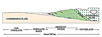
The pattern of sedimentation from this rifting environment continued into the Penokean orogeny, which is the next major tectonic event in the Great Lakes region.
[5]: 409 In the Marquette area, the GLTZ is a northwest-striking zone of metamorphic rock about 2 km (1.2 mi) wide that was crushed by the dynamics of tectonic movements.
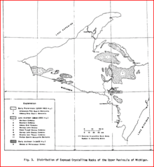
[8]: 4 Recent radiometric age data indicates that there are four crystalline rock complexes 3,400 million years old in the Lake Superior region.
[8]: 3 Rocks exposed in the Minnesota River Valley include a complex of migmatitic granitic gneisses, schistose to gneissic amphibolite, metagabbro and paragneisses.
[9] The Sacred Heart granitic bodies that occur along portions of the Minnesota River Valley are relatively unfractured and unfoliated, and may represent passive intrusions into folded metasedimentary rocks.
[8]: 8 It is a typical late-tectonic medium-grained pink granite that was intruded around 2,600 million years ago, after the suturing of the MRV gneissic terrane onto the Superior province.
[4] Late Archean lithologies in northwestern Wisconsin and the Upper Peninsula of Michigan are similar to the Sacred Heart granite and consist of gneisses and migmatites.
[8]: 1 Some of the Penokean granites show iron enrichment similar to the magnetite series, rather than the low-oxygen concentration of the magnetic titanium oxides.
[8]: 3 The folding and metamorphism increased in intensity to the south and southeast,[8]: 1 and produced the isolated gneissic 1,755-million-year-old[2]: 342 Watersmeet Domes which straddle the border of Michigan and northeastern Wisconsin.
[11] In the eastern Sudbury area the rock is highly crystalline hornblendic gneiss, which apparently dips at a rather low angle toward the southeast.
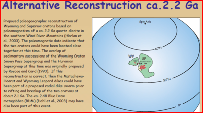
[6]: 147 An episode of hotspot gabbro magmatism occurred 2,480 million years ago at the eastern edge of the Wyoming craton,[13]: 1 south of current-day Sudbury.
The final assembly of supercontinent Kenorland was finished by 2,600 to 2,550 million years ago; the southern Superior province – with the Minnesota River Valley subprovince attached – and the current-day southeastern border of the Wyoming province abutted each other from the Sudbury area westerly about 625 km (390 mi) to the Wisconsin-Michigan state line on Lake Superior.
[13]: 2 Radiometric dating shows that the Wyoming province's Blue Draw Metagabbro was undergoing rifting at 2,480 million years ago, the same time the emplacement of the 250 km (160 mi) long belt of mafic layered intrusions in the Sudbury region.
[13]: 9 In the northern Black Hills of southwest South Dakota the 2,600- to 2,560-million-year-old Precambrian crystalline core, the Blue Draw Metagabbro, is a 1 km (0.62 mi) thick layered sill.
[13]: 2 The 2,125- to 2,101-million-year-old Marathon and 2,077- to 2,076-million-year-old Fort Frances dikes, both on the present-day Superior province north of the Great Lakes tectonic zone, are consistent with rifting during this time period.
[15] The best-documented event occurred on July 9, 1975, near Morris, Minnesota, with a magnitude of 4.6, and a felt area of 82,000 km2 (32,000 sq mi) covering parts of four states.