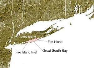
Great South Bay
[3] Long Island's South Shore, adjacent to the bay, now includes the communities of Lindenhurst, Babylon, Islip, Oakdale, Sayville, Bayport, Blue Point, Patchogue, Bellport, Shirley, and Mastic Beach.
In the late nineteenth century Great South Bay provided many of the clams consumed throughout the region and even the country.
[4] Hurricane Sandy in 2012, the largest storm to affect the region since 1938, made landfall with devastating impact to Fire Island seashores, including multiple breaches.
[6] Regulations set forth by the US Government National Wildlife Preserve, which has a seven-mile stretch of land (the Otis Pike Fire Island High Dune Wilderness) prohibit any unauthorized parties from performing any kind of man-made changes, thus the inlet has remained open.
In 2012, The Save the Great South Bay (STGSB) not-for-profit organization was formed in order to work towards better conservation of the water and its beachfronts.