Great Zimbabwe
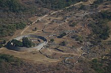
The Great Enclosure, with its 11m (36 ft) high dry stone walls (that is, constructed without mortar), was built during the 13th and 14th centuries, and likely served as the royal residence, with demarcated public spaces for rituals.
[6] The earliest document mentioning the Great Zimbabwe ruins was in 1531 by Vicente Pegado, captain of the Portuguese garrison of Sofala on the coast of modern-day Mozambique, who recorded it as Symbaoe.
[12] The Great Zimbabwe area was previously settled by the San dating back 100,000 years,[a] and by Bantu-speaking peoples from 150 BC who formed agricultural chiefdoms from the 4th century AD.
[9][15] These are the earliest Iron Age settlements in the area identified from archaeological diggings, and the later Gumanye people are considered the ancestors of the Karanga (south-central Shona), who would construct Great Zimbabwe.
[24][25] In 1531, Vicente Pegado, Captain of the Portuguese Garrison of Sofala, described Zimbabwe thus:[10] Among the gold mines of the inland plains between the Limpopo and Zambezi rivers there is a fortress built of stones of marvelous size, and there appears to be no mortar joining them ...
[29] Dhaka pits were closed depressions utilized by inhabitants of Great Zimbabwe as sources of water management in the form of reservoirs, wells and springs.
[38] Regional networks were expansive, and salt, cattle, grain, and copper were traded as far north as the Kundelungu Plateau in present-day DR Congo.
[b] It is unclear to what extent climate change played a role, however Great Zimbabwe's location in a favourable rainfall zone makes this unlikely to have been a primary cause.
Great Zimbabwe's dominance over the region depended on its continual extension and projection of influence, as its growing population needed more farming land and traders more gold.
[45] From the early 15th century, international trade began to decline amid a global economic downturn, reducing demand for gold, which adversely affected Great Zimbabwe.
By the late 15th century, the consequences of this decision began to manifest, as, according to oral tradition, Nyatsimba Mutota, a member of Great Zimbabwe's royal family, led part of the population north in search for salt to found the Mutapa Empire.
[50] The first European visit may have been made by the Portuguese traveler António Fernandes in 1513–1515, who crossed twice and reported in detail the region of present-day Zimbabwe (including the Shona kingdoms) and also fortified centers in stone without mortar.
[51][52] Portuguese traders heard about the remains of the medieval city in the early 16th century, and records survive of interviews and notes made by some of them, linking Great Zimbabwe to gold production and long-distance trade.
[54][55] In 1506, the explorer Diogo de Alcáçova described the edifices in a letter to Manuel I of Portugal, writing that they were part of the larger kingdom of Ucalanga (presumably Karanga, a dialect of the Shona people spoken mainly in Masvingo and Midlands provinces of Zimbabwe).
[56] João de Barros left another such description of Great Zimbabwe in 1538, as recounted to him by Moorish traders who had visited the area and possessed knowledge of the hinterland.
Karl Mauch recorded the ruins 3 September 1871, and immediately speculated about a possible Biblical association with King Solomon and the Queen of Sheba, an explanation which had been suggested by earlier writers such as the Portuguese João dos Santos.
Mauch went so far as to favour a legend that the structures were built to replicate the palace of the Queen of Sheba in Jerusalem,[61] and claimed a wooden lintel at the site must be Lebanese cedar, brought by Phoenicians.
He asserted that the figurine instead appeared to date to the subsequent Ptolemaic era (c. 323–30 BC), when Alexandria-based Greek merchants would export Egyptian antiquities and pseudo-antiquities to southern Africa.
[65] J. Theodore Bent undertook a season at Zimbabwe with Cecil Rhodes's patronage and funding from the Royal Geographical Society and the British Association for the Advancement of Science.
By the third edition of his book (1902) he was more specific, with his primary theory being "a Semitic race and of Arabian origin" of "strongly commercial" traders living within a client African city.
The construction of Great Zimbabwe is also claimed by the Lemba, as documented by William Bolts in 1777 (to the Austrian Habsburg authorities), and by an A.A. Anderson (writing about his travels north of the Limpopo River in the 19th century).
[citation needed] Lemba speak the Bantu languages spoken by their geographic neighbours, but they have some religious practices and beliefs similar to those in Judaism and Islam, which they claim were transmitted by oral tradition.
In Medieval Rhodesia, he rejected the claims made by Adam Render, Carl Peters and Karl Mauch, and instead wrote of the existence in the site of objects that were of Bantu origin.
She had first sunk three test pits into what had been refuse heaps on the upper terraces of the hill complex, producing a mix of unremarkable pottery and ironwork.
Some further test trenches were then put down outside the lower Great Enclosure and in the Valley Ruins, which unearthed domestic ironwork, glass beads, and a gold bracelet.
[101] Martin Hall writes that the history of Iron Age research south of the Zambezi shows the prevalent influence of colonial ideologies, both in the earliest speculations about the nature of the African past and in the adaptations that have been made to contemporary archaeological methodologies.
[103] Preben Kaarsholm writes that both colonial and black nationalist groups invoked Great Zimbabwe's past to support their vision of the country's present, through the media of popular history and of fiction.
[53][104] Gertrude Caton-Thompson recognised that the builders were indigenous Africans, but she characterised the site as the "product of an infantile mind" built by a subjugated society.
At first it was argued that it represented a form of pre-colonial "African socialism" and later the focus shifted to stressing the natural evolution of an accumulation of wealth and power within a ruling elite.
They hold the government responsible for the "silence" and "closure" of Great Zimbabwe due to their refusal to "acknowledge the ownership and control of the site by the ancestors and Mwari".