Grote rivieren
The Grote rivieren, literally translated Great (or Large) rivers, is a landform in the Netherlands.
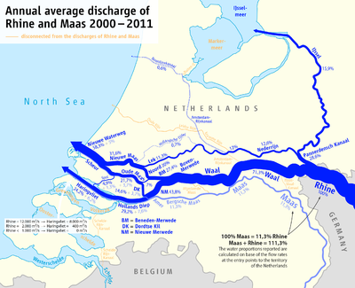
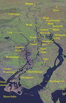
The term Grote rivieren refers to the division of the Netherlands by the Nederrijn, Lek, Waal, Merwede and Meuse rivers, which dominate an area roughly 150 km in length from west to east and 25 km wide from north to south.
To aid in the transport of goods through the Great rivers, many canals have been dug to improve connectivity with nearby cities, most notably the Amsterdam-Rhine Canal, which links up the Grote rivieren with the cities of Utrecht and Amsterdam, including the Port of Amsterdam.
Various cultural differences are associated with this border, including dialectical differences (such as the use of the so-called Hard G in the north and the soft G in the south) and sociological ones (with northerners being considered more direct, austere, and goal oriented and southerners more indirect, easy-going, and status oriented).
[1] The cultural differences play a part in daily life within the Dutch-speaking region and are factors in personal identification among its inhabitants.